Wangerland
Wangerland is a municipality in the district of Friesland, Lower Saxony, Germany. It is situated on the North Sea coast, approximately 20 km northwest of Wilhelmshaven, and 10 km north of Jever. Its seat is in the village Hohenkirchen.
Wangerland | |
|---|---|
 Coat of arms | |
Location of Wangerland within Friesland district 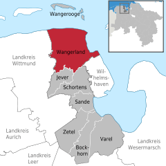  | |
 Wangerland  Wangerland | |
| Coordinates: 53°39′N 7°57′E | |
| Country | Germany |
| State | Lower Saxony |
| District | Friesland |
| Subdivisions | 14 quarters |
| Government | |
| • Mayor | Björn Mühlena (Ind.) |
| Area | |
| • Total | 176 km2 (68 sq mi) |
| Elevation | 2 m (7 ft) |
| Population (2018-12-31)[1] | |
| • Total | 9,190 |
| • Density | 52/km2 (140/sq mi) |
| Time zone | CET/CEST (UTC+1/+2) |
| Postal codes | 26434, 26441 (Groß Hauskreuz) |
| Dialling codes | 04463, 04464, 04461, 04425, 04426 |
| Vehicle registration | FRI |
| Website | www.wangerland-online.de |
History
First settlements are dated on the 2nd century B.C.
Subdivision
The municipality consists of the following villages: Altgarmssiel, Förrien, Friederikensiel, Hohenkirchen, Hooksiel, Horumersiel, Middoge, Minsen, Neugarmssiel, Oldorf, Schillig, Tettens, Waddewarden and Wiarden.[2]
gollark: What generator?
gollark: Not a compact machine sized fission reactor, three fusion reactors.
gollark: NuclearCraft? I can finally bring my compact machine reactor design to this! (It's just compact machine sized, doesn't really need Compact Machines).
gollark: RFTools and maybe Compact Machines.
gollark: Ah, a shame. BiblioCraft has tinted glasses.
References
External links
- Official site (in German)
- Churches in Wangerland (in German)
Towns and municipalities in Friesland (district) | ||
|---|---|---|
Coat of arms | ||
| Authority control |
|
|---|
This article is issued from Wikipedia. The text is licensed under Creative Commons - Attribution - Sharealike. Additional terms may apply for the media files.