Hokkaidō montane conifer forests
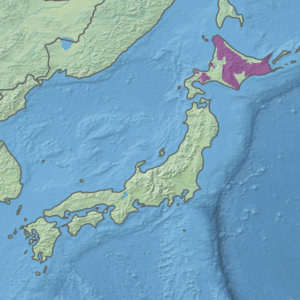
The Hokkaido montane conifer forests ecoregion (WWF ID:PA0510) covers the mountainous central regions of Hokkaido Island, the northermost of Japan's main islands.[1][2] Forests of spruce and fir thrive in the subalpine, cool climate. On the northeastern edge of the island, the conifer forests extend down to the sea under the influence of the cold Oyashio Current coming down from the north, although logging in recent years has put pressure on these stands.
| Ecoregion: Hokkaido montane conifer forests | |
|---|---|
Mt. Sapporo | |
 Ecoregion territory (in purple) | |
| Ecology | |
| Realm | Palearctic |
| Geography | |
| Area | 45,843 km2 (17,700 sq mi) |
| Country | Japan |
| Coordinates | 43.25°N 143.25°E |
Location and description
The mountainous region is surrounded by the lower plains and hills of the Hokkaidō deciduous forests ecoregion. Central to the region is the Daisetsuzan Volcanic Group, the location of Daisetsuzan National Park, the largest national park in Japan.[1] The highest mountain on the island, and in the region, is Asahi-dake with an elevation of 2,290 metres (7,510 ft).[1] Above the conifer line, alpine conditions support thickets of Stone pine (Pinus pumila)
Climate
The climate of the ecoregion is Humid continental climate, warm summer (Köppen climate classification (Dfb)). This climate is characterized by large seasonal temperature differentials and a warm summer (at least four months averaging over 10 °C (50 °F), but no month averaging over 22 °C (72 °F).[3][4] Average annual precipitation is 1,150 mm.
Flora and fauna
The dominant trees in the region are Ezo spruce (Picea jezoensis), Sakhalin fir (Abies sachalinensis), and Skhalin spruce (Picea glehnii). There are scattered stands of Erman's birch (Betula ermanii). The conifer belt rises to an altitude of 1,500 metres (4,900 ft).
Protected areas
- Daisetsuzan National Park
- Akan Mashu National Park
- Kushiro-shitsugen National Park
- Shikotsu-Tōya National Park
References
- "Hokkaido montane conifer forests". World Wildlife Federation. Retrieved March 21, 2020.
- "Map of Ecoregions 2017". Resolve, using WWF data. Retrieved September 14, 2019.
- Kottek, M., J. Grieser, C. Beck, B. Rudolf, and F. Rubel, 2006. "World Map of Koppen-Geiger Climate Classification Updated" (PDF). Gebrüder Borntraeger 2006. Retrieved September 14, 2019.CS1 maint: multiple names: authors list (link)
- "Dataset - Koppen climate classifications". World Bank. Retrieved September 14, 2019.