Highland Range (Clark County)
The Highland Range of Clark County, Nevada, is a small 10-mile (16 km) long,[1] range south of Henderson, Nevada and separated from the southeast flank of the McCullough Range by a narrow, approximately three-mile wide valley, at the head of Piute Wash.[2]
| Highland Range | |
|---|---|
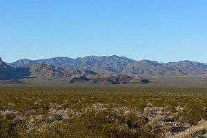
 Highland Range northwest of Eldorado Valley (foreground) | |
| Highest point | |
| Peak | Castle Peak 4879 ft., Northwest part of range |
| Elevation | 4,879 ft (1,487 m) |
| Coordinates | 35°38.94′N 115°02.93′W |
| Dimensions | |
| Length | 10 mi (16 km) N-S |
| Geography | |
 Highland Range Highland Range of Clark County, Nevada | |
| Country | United States |
| State | Nevada |
| District | Clark County |
| Settlement | Searchlight |
| Borders on | McCullough Range-W Eldorado Valley-N, NE & SE Piute Wash- SW |
| Topo map | USGS McCullough Mtn., Nevada 15 minute Topo Quad, 1960 |
The Highland Range also lies on the southwest border region of the endorheic Eldorado Valley. The Highland Range Crucial Bighorn Habitat Area is a large part of the range's north, and also the alluvial plains on the northeast above Eldorado Valley.[1]
Description
The Highland Range is about 10 miles long.[1] A north section with a ridgeline extends somewhat into Eldorado Valley; the center and southeast gradually lower in elevation toward the southern margin of Eldorado Valley, just to the northwest of the mining area around Searchlight. The southern end of the Eldorado Mountains, which form the eastern margin of Eldorado Valley, lies just to the northeast of Searchlight.[3][4]
U.S. Route 95 runs south through Eldorado Valley to the east of the Highlands to Searchlight. Nevada State Route 164 runs west from Searchlight through Paiute Wash.[1]
References
- Nevada Atlas & Gazetteer, DeLorme, c. 2010, p. 72
- McCullough Mtn., Nevada, 15 Minute Topographic Quadrangle, USGS, 1960
- Nelson, Nevada, 15 Minute Topographic Quadrangle, USGS, 1958
- Searchlight, Nevada–California, 15 Minute Topographic Quadrangle, USGS, 1959