Highland Avenue (Atlanta)
Highland Avenue, east of the BeltLine North Highland Avenue, is a major thoroughfare in northeast Atlanta, forming a major business corridor connecting five Intown neighborhoods:
- Highland Avenue begins at Central Park Place NE in the Old Fourth Ward and proceeds eastward past the Atlanta Medical Center and crossing Freedom Parkway a first time.
- It crosses the BeltLine where it becomes North Highland Avenue NE and forms the main retail and entertainment street of Inman Park.
- North Highland Avenue then bends north and crosses Freedom Parkway again, entering the Poncey-Highland neighborhood which takes part of its name from the avenue.
- It then crosses Ponce de Leon Avenue, entering Virginia-Highland, the second neighborhood to take part of its name from the avenue.
- Crossing Amsterdam Ave., North Highland Ave. enters Morningside/Lenox Park, then ends at the intersection with Johnson Road.[1]
Streetscape in Inman Park
Streetscape in Inman Park
Druid Hills Baptist Church at the southeast corner of North Highland and Ponce de Leon Avenue
Plaza Theatre at Briarcliff Plaza, southwest corner of North Highland and Ponce de Leon Avenue

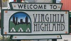
Virginia-Highland welcome sign at the corner of North Highland and Virginia Avenue
Business districts
The North Highland corridor connects multiple small business districts within each neighborhood in Morningside, Virginia-Highland, Poncey Highland, Inman Park and the Old Fourth Ward. Local businesses market the corridor as the "Highland Corridor".[2][3]
Events
The same Highland corridor is the focus of one of the annual Atlanta Streets Alive pedestrian and cycling events.[4]
Traffic
North Highland Avenue is the focus of a traffic and pedestrian study by the City of Atlanta.[5]
gollark: Anyone want to download a car?
gollark: My Opus SNMP ping trilaterator seems to work okay.
gollark: The what?
gollark: I actually updated the licenses recently so you should probably read it if you use potatOS, have read the license agreement, know anyone who has read the license agreement, or know about the license agreement.
gollark: https://pastebin.com/NdUKJ07j
References
- "Map of Highland Ave., Atlanta, Georgia". OSM.org. Open Street Map. Retrieved June 1, 2018.
- "Local Businesses Publish Highland Corridor Map". Virginia-Highland Voice. December 3, 2012 – via vahi.org.
- "Highland Corridor map" (PDF). Virginia-Highland Voice – via vahi.org.
- "The Route: October 6, 2013 • 2-6PM Highland/Monroe-Boulevard/Virginia". AtlantaStreetsAlive.com. Atlanta Streets Alive. October 6, 2013. Archived from the original on November 4, 2013.
- "North Highland Avenue Study". atlantaga.gov. Bureau of Planning, Department of Planning, Development and Neighborhood Conservation, City of Atlanta. December 1999. Retrieved June 1, 2018.
External links
- "North Highland Avenue at the BeltLine", photos of transformation
- "Flashback Fotos: Journey Down Highland Avenue", Atlanta Journal-Constitution site - online gallery of historic photos of North Highland Avenue
This article is issued from Wikipedia. The text is licensed under Creative Commons - Attribution - Sharealike. Additional terms may apply for the media files.