Herøy Bridge
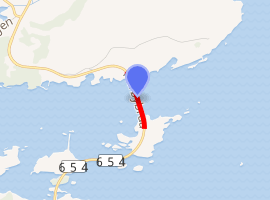
The Herøy Bridge (Norwegian: Herøybrua) is a cantilever bridge that connects the islands of Gurskøya and Leinøya in the municipality of Herøy in Møre og Romsdal county, Norway. It is part of a bridge network which connects all of the main islands of the municipality together. It is about 8 kilometres (5.0 mi) southeast of Fosnavåg.
Herøy Bridge Herøybrua | |
|---|---|
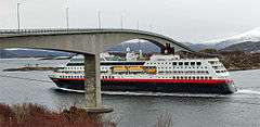 View of the Herøy Bridge | |
| Coordinates | 62°19′10″N 5°43′15″E |
| Carries | Riksvei 654 |
| Crosses | Røyrasundet |
| Locale | Herøy, Møre og Romsdal, Norway |
| Characteristics | |
| Design | Cantilever bridge |
| Total length | 544 m (1,785 ft) |
| Longest span | 170 m (560 ft) |
| Clearance below | 32 m (105 ft) |
| History | |
| Opened | 1976 |
| Inaugurated | 4 September 1976 |
| |
The bridge is 544 metres (1,785 ft) long, the longest span is 170 metres (560 ft), and the maximum clearance to the sea is 32 metres (105 ft). Herøy Bridge was opened by King Olav V on 4 September 1976.[1]
See also
- Remøy Bridge
- Runde Bridge
- Nerlandsøy Bridge
- List of bridges in Norway
- List of bridges in Norway by length
- List of bridges
- List of longest bridges in the world
References
- Store norske leksikon. "Herøybrua" (in Norwegian). Retrieved 2010-09-19.
This article is issued from Wikipedia. The text is licensed under Creative Commons - Attribution - Sharealike. Additional terms may apply for the media files.