Helle, Telemark
Helle is a village in the Kragerø municipality of Telemark, Norway, located on the north shores of Hellefjorden about 7 km (4.3 mi) northeast of the city of Kragerø.
Helle Vadfoss/Helle | |
|---|---|
Village | |
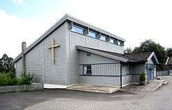
 Hellekirken | |
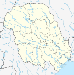
 Helle Location of Helle in Telemark  Helle Helle (Norway) | |
| Coordinates: 58°54′4.5″N 9°22′44″E | |
| Country | Norway |
| Region | Eastern Norway |
| County | Telemark |
| District | Vestmar |
| Municipality | Kragerø |
| Area | |
| • Total | 1.59 km2 (0.61 sq mi) |
| Population (2012)[1] | |
| • Total | 1,556 |
| • Density | 979/km2 (2,540/sq mi) |
| Time zone | UTC+01:00 (CET) |
| • Summer (DST) | UTC+02:00 (CEST) |
| Post Code | 3790 Helle |
For the purpose of the Norwegian census the village is combined with its neighbor village to the west, Vadfoss, and listed as Vadfoss/Helle. As of January 2012, the Vadfoss/Helle area has a population of 1,556 over an area of 1.59 km2 (0.61 sq mi), giving it a density of 979 inhabitants per square kilometre (2,540 inhabitants per square mile).[1] Helle includes the neighborhoods of Nordbø, Sollia, Måneliheia and Skarbo. Lakes in the area include Upper and Lower Strandtjenn, Langtjenn, Bastautjenn, Årømyrtjenna and Svarttjenn.
The village is connected to the rest of Norway via road by Fylkesvei 363 and 210, and via bus by Nettbuss Sør Route 459[2] and Drangedal Bilruter Route 609.[3] The nearest E-road is the E18, which passes through Sannidal to the west.
History
Helle started out as an industrial community when the Helle Bruk sawmill was built in 1580.[4] The sawmill was in continuous operation until 1930 when it was shut down. The village was also known for its ice harvesting industry, and at one point it had three different companies exporting ice from the area. There was also a chains factory in the Skarbo neighborhood with about 45 employees that was founded in 1909. It was in continuous operation up until 2005 when the company moved operations to an industrial park on the border of Kragerø and Drangedal just north of the E18.[5]
Today, Helle is largely a residential community, with the exception of a few businesses on Helleveien. In the Sollia neighborhood there is a small wooden church, Hellekirken, which was built in 1994. The church includes a kindergarten, a kitchen, multiple meeting rooms, and a chapel with 200 seats.[6] There was formerly a small post office in the village center, but it closed around the turn of the millennium. In 2008, a large new elementary school, Helleskolen, was built in the Nordbø neighborhood to replace Årø School and Skarbo School. It houses about 200 students and includes sports facilities such as an artificial turf field.[7]
References
- Statistics Norway (2012). "Urban settlements. Population and area, by municipality. 1 Jan 2012". Archived from the original on 20 November 2012. Retrieved 16 Jan 2013. Cite journal requires
|journal=(help) - "Route Booklet Grenland & Kragerø 01.01.13" (in Norwegian). Nettbuss. 1 Jan 2013. Retrieved 16 Jan 2013. Check date values in:
|year= / |date= mismatch(help) - "609 Kragerø-Helle-Tangen" (in Norwegian). Drangedal Bilruter. 9 Dec 2012. Archived from the original on 2013-01-16. Retrieved 16 Jan 2013.
- "Kalstad and Helle" (in Norwegian). Visit Kragerø. Archived from the original on 13 May 2012. Retrieved 16 Jan 2013.
- "Welcome to Kjættingfabriken AS" (in Norwegian). FRAM Kjættingfabriken AS. Archived from the original on 24 May 2012. Retrieved 20 Jan 2013.
- "The population of Helle have built a church" (in Norwegian). The Kragerø Churches. Archived from the original on 16 January 2012. Retrieved 16 Jan 2013.
- Eckholdt, Per (25 May 2008). "Construction begins on Helleskolen" (in Norwegian). Kragerø Blad Vestmar. Retrieved 16 Jan 2013.