Hayden Peak (Utah)
Hayden Peak is a peak on the western edge of the High Uintas Wilderness in the Uinta-Wasatch-Cache National Forest in the western Uinta Mountain Range Summit County, Utah, United States.[1]
| Hayden Peak | |
|---|---|
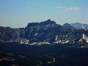 The west face of Hayden Peak, July 2008 | |
| Highest point | |
| Elevation | 12,484 ft (3,805 m) [1] |
| Prominence | 1,151 ft (351 m) [2] |
| Coordinates | 40°44′08″N 110°50′39″W [2] |
| Geography | |
| Location | Summit County, Utah, United States |
| Parent range | Uinta Mountains |
| Topo map | USGS Hayden Peak |
| Climbing | |
| Easiest route | Hike |
Description
The mountain is home to mountain goats, pika and many species of wildflowers. The peak is named for Ferdinand Hayden, an American geologist noted for his pioneering surveying expeditions of the Rocky Mountains in the late 19th century.[3]
gollark: Depends what you mean, and also why would you want that?
gollark: They're an obvious system. I think you overestimate their stability though.
gollark: That's not very opposite.
gollark: As supreme eternal dictator, I would totally do this. As such, I am to be.
gollark: Where would they escape to? There are no good countries, with me as supreme eternal dictator.
References
- U.S. Geological Survey Geographic Names Information System: Hayden Peak
- "Hayden Peak, Utah". Peakbagger.com. Retrieved 2009-07-10.
- "Glad You Asked: What Mountain Range Honours Prominent Geoscientists". Utah Geological Survey. Retrieved 2016-04-18.
This article is issued from Wikipedia. The text is licensed under Creative Commons - Attribution - Sharealike. Additional terms may apply for the media files.