Hawaii Route 92
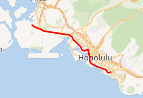
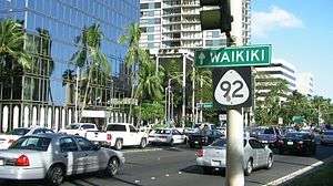
Route 92 is a major east–west highway on the island of Oahu which begins at exit 15 off Interstate H-1 (H-1) in Honolulu and ends 0.6 miles (0.97 km) east of the Ala Wai Canal crossing in Waikiki. The western portion, west of Richards Street, is locally known as the Nimitz Highway (named after Pacific Fleet Admiral during World War II, Chester Nimitz). East of Richards Street, Route 92 is locally known as Ala Moana Boulevard.
| ||||
|---|---|---|---|---|
| ||||
| Route information | ||||
| Maintained by HDOT | ||||
| Length | 9.3 mi[1] (15.0 km) | |||
| Major junctions | ||||
| West end | JB Pearl Harbor–Hickam in Honolulu | |||
| East end | Kalakaua Avenue in Honolulu | |||
| Location | ||||
| Counties | Honolulu | |||
| Highway system | ||||
Routes in Hawaii
| ||||

Route description
After exiting H-1, Route 92 goes past the Pearl Harbor Naval Base and Hickam Air Force Base gates. Route 92 goes under the Airport Viaduct (H-1) and serves primary route for Honolulu International Airport. Route 92 briefly runs underneath H-1 before exiting again at exit 18. Heading east, Route 92 enters into the Port of Honolulu and downtown Honolulu. After crossing the Ala Wai Canal to Waikiki, Route 92 ends, and county jurisdiction is transferred at that point.
History
The route was constructed in the 1940s during World War II to serve military facilities and the local airport. There were plans in the 1960s to extend the road east of the Ala Moana Shopping Center toward H-1 once again, but those plans were dropped by the late 1970s.
Major intersections
The entire route is in Honolulu, Honolulu County.
| mi[1] | km | Destinations | Notes | ||
|---|---|---|---|---|---|
| 0.0 | 0.0 | Naval Base | Restricted access | ||
| 0.5 | 0.80 | Hickam AFB | Interchange with O'Malley Boulevard; westbound exit and eastbound entrance | ||
| 0.8 | 1.3 | No westbound access to H-1 east; exit 15 on H-1 | |||
| 1.8 | 2.9 | ||||
| 2.9 | 4.7 | Puuloa Road – Honolulu | |||
| 3.2 | 5.1 | Eastbound exit and westbound entrance; exit 18 on H-1 | |||
| 3.7 | 6.0 | Westbound exit and eastbound entrance; exit 18A on H-1 | |||
| 4.0 | 6.4 | Northern terminus of Route 64 | |||
| 4.4 | 7.1 | Southern terminus of Route 63 | |||
| 6.5 | 10.5 | Alakea Street (Route 7504) – Downtown Honolulu | |||
| 9.3 | 15.0 | Kalakaua Avenue (Route 7612) / Pau Street (Route 7715) to Kuhio Avenue / Ala Wai Boulevard | |||
| 1.000 mi = 1.609 km; 1.000 km = 0.621 mi | |||||
References
- Google (June 22, 2018). "Hawaii Route 92" (Map). Google Maps. Google. Retrieved June 22, 2018.