Hatillo, Hatillo, Puerto Rico
Hatillo is a barrio in the municipality of Hatillo, Puerto Rico. Its population in 2010 was 3,806.[3][4][5]
Hatillo | |
|---|---|
Barrio | |
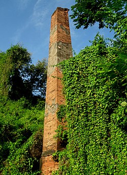 Old smoke stack, a little distance from Santa Rosa in Hatillo | |
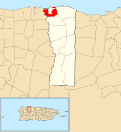 Location of Hatillo within the municipality of Hatillo shown in red | |
 Hatillo Location of Puerto Rico | |
| Coordinates: 18°28′43″N 66°49′03″W[1] | |
| Commonwealth | |
| Municipality | |
| Area | |
| • Total | 1.81 sq mi (4.7 km2) |
| • Land | 1.60 sq mi (4.1 km2) |
| • Water | 0.21 sq mi (0.5 km2) |
| Elevation | 52 ft (16 m) |
| Population (2010) | |
| • Total | 3,806 |
| • Density | 2,393.7/sq mi (924.2/km2) |
| Source: 2010 Census | |
| Time zone | UTC−4 (AST) |
History
The United States took control of Puerto Rico from Spain in the aftermath of the Spanish-American War under the terms of the Treaty of Paris of 1898. In 1899, the United States conducted its first census of Puerto Rico finding that the population of Hatillo barrio was 676.[6]
Sectors
Barrios (which are like minor civil divisions)[7] in turn are further subdivided into smaller local populated place areas/units called sectores (sectors in English). The types of sectores may vary, from normally sector to urbanización to reparto to barriada to residencial, among others.[8][9][10][11]
gollark: No, that was caused by potatOS bricking itself one time due to a bug.
gollark: *Helpful* potatoes, remember that.
gollark: They're totally not the poisonous ones.
gollark: I sell *helpful* potatoes.
gollark: QUITE EASILY
See also
References
- "US Gazetteer 2019". US Census. US Government.
- U.S. Geological Survey Geographic Names Information System: Hatillo barrio
- Picó, Rafael; Buitrago de Santiago, Zayda; Berrios, Hector H. Nueva geografía de Puerto Rico: física, económica, y social, por Rafael Picó. Con la colaboración de Zayda Buitrago de Santiago y Héctor H. Berrios. San Juan Editorial Universitaria, Universidad de Puerto Rico,1969.
- Gwillim Law (20 May 2015). Administrative Subdivisions of Countries: A Comprehensive World Reference, 1900 through 1998. McFarland. p. 300. ISBN 978-1-4766-0447-3. Retrieved 25 December 2018.
- Puerto Rico:2010:population and housing unit counts.pdf (PDF). U.S. Dept. of Commerce, Economics and Statistics Administration, U.S. Census Bureau. 2010.
- Joseph Prentiss Sanger; Henry Gannett; Walter Francis Willcox (1900). Informe sobre el censo de Puerto Rico, 1899, United States. War Dept. Porto Rico Census Office (in Spanish). Imprenta del gobierno. p. 158.
- "US Census Barrio-Pueblo definition". factfinder.com. US Census. Archived from the original on 13 May 2017. Retrieved 5 January 2019.
- "Agencia: Oficina del Coordinador General para el Financiamiento Socioeconómico y la Autogestión (Proposed 2016 Budget)". Puerto Rico Budgets (in Spanish). Retrieved 28 June 2019.
- Rivera Quintero, Marcia (2014), El vuelo de la esperanza: Proyecto de las Comunidades Especiales Puerto Rico, 1997-2004 (first ed.), San Juan, Puerto Rico Fundación Sila M. Calderón, ISBN 978-0-9820806-1-0
- "Leyes del 2001". Lex Juris Puerto Rico (in Spanish). Retrieved 24 June 2020.
- "PRECINTO ELECTORAL HATILLO 029" (PDF). Comisión Estatal de Elecciones (in Spanish). PR Government. 17 October 2019. Retrieved 28 July 2020.
This article is issued from Wikipedia. The text is licensed under Creative Commons - Attribution - Sharealike. Additional terms may apply for the media files.