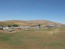
Haticepinar
Haticepınar is a village of Afşin in Kahramanmaraş Province in Turkey. Haticepinar is located in Turkey inhabited by Kurdish people.
History
Haticepinar has acquired the status of a village in 1950 and according to the knowledge of the elderly who still reside in Haticepinar acclaim that people first settled in the area as far as 130 to 150 years ago. Inhabitants of Haticepinari are related to the nearby village of Kaşanlı. The name Kaşanlı is derived from the Kasan city in Iran and according to the elderly of the region Kurdish people that were oppressed by the Persian King left the city of Kasan moving north-west and eventually settling in the current area.
Culture
People of Haticepinari are Kurdish hence the main language spoken is Kurdish (Kurmanji dialect) language. Local people have retained their Kurdish traditions that include the traditional dressing code, Kurdish cuisine and special methods of cooking. Traditional folk dance is still performed by the local people at occasions such as weddings and musical instruments such as Baglama and Kaval are played by majority of the people.
Geography
Haticepinar is 55 km away from Afşin and 205 km from Kahramanmaraş Province.

Haticepinar is located on the mountainous region of the Binboğa Mountains and for this arable lands are limited. On the west of the village is the village of Oglakkaya, on the south is the Orenli village, on the north is the Guldede village of Gürün and on the east are the neighbouring Kavak villages.
Climate
Altitude wise, Haticepinar is the highest village of the local region. This has led to the area experiencing significantly colder winters with heavy snowfall. Despite its colds winters, summer season at Haticepinar is very warm with temperatures rising to as high as 38-40°C.
Population
According to Government Statistics Institution there are 70 houses in the village and 1990 census shows that the population was 176, in 1997 census the population had dropped to 124. In 2009 the figure was 84.[1]
Economy
Due to declining agricultural resources of the area the increasing population could not be supported with the available resources and this has led to migration to larger cities or even to several European countries or other continents. The current economy still relies of agriculture and farming. In recent years, apricots have been produced although this is not at a large scale. Other crops that are grown in the area include wheat, barley and chickpeas. Dairy products are obtained from the cows, sheep and goats that are owned by the inhabitants.
Other information
Haticepinar has a primary school that is currently not in use due to shortage of teachers in the region.
Water for domestic use and for drinking is obtained from the several wells in the village and there are also two fountains. Work has been started in 2005 to build water system to homes which is due to completion in summer of 2007. The village has no health care clinic with local/regional nurses visiting the village a few times a year.
The main transport link to major towns is a gravel road.
Haticepinar has electricity but no telephone services therefore people have to travel to nearby villages that have telephone services.
10-15 Minutes from the village is the Maden Dagi (Mine Mountain) which has one of the richest marble mines of the region. In the recent years government lead companies have excavated the top of the mountain and marbles were obtained which were then used mainly in building work, decorations or as exports.
References
- "Population of city, towns and villages - 2009". Turkish Statistical Institute. Archived from the original on 2012-04-25. Retrieved 2020-05-04.