Hangers Way
Hangers Way is a 21-mile-long-distance (34 km) footpath through Hampshire, England from Alton railway station to Queen Elizabeth Country Park where it meets the South Downs Way National Trail.
| Hangers Way | |
|---|---|
| Length | 21 mi (34 km) |
| Location | Hampshire, England |
| Trailheads | Alton 51.152°N 0.967°W Queen Elizabeth Country Park 50.9614°N 0.9781°W |
| Use | Hiking |
The name Hanger comes from the Old English word hangra, meaning a steeply wooded slope.[1]
The footpath passes through Petersfield and Selborne along a series of steep-sided wooded hills, known as "The Hangers", and can be walked in either direction. The route can be used with the part of St Swithun's Way from Farnham to Alton to follow the geological edge of the chalk landscape between the North Downs and the South Downs.
The footpath is waymarked by metal and plastic disks found attached to wooden and metal posts, trees and street furniture. The waymarks are green and show a slope with a single tree.
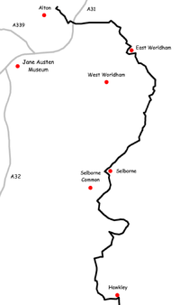
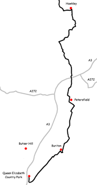
The route
These maps show the footpath in relation to nearby major roads and towns.
See also
- Recreational walks in Hampshire
- Long-distance footpaths in the UK
References
- "Anglo Saxon Dictionary". Retrieved 28 May 2020.