Hanang District
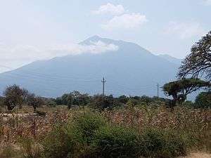
Hanang District is one of the six districts of the Manyara Region of Tanzania. It is bordered to the north by the Mbulu District and Babati Rural District, to the southeast by the Dodoma Region and to the southwest by the Singida Region. Mount Hanang is located within the boundaries of the district.
Hanang District | |
|---|---|
 | |
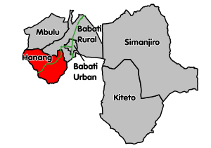 Hanang District's location within Manyara Region | |
| Country | Tanzania |
| Region | Manyara Region |
| Population (2012) | |
| • Total | 275,990 |
| Website | www |
According to the 2002 Tanzania National Census, the population of the Hanang District was 205,133.[1] According to the 2012 Tanzania National Census, the population of Hanang District was 275,990.[2]
The District Commissioner of the Hanang District is Moses B. Sanga.[3]
Administrative subdivisions
As of 2012, Hanang District was administratively divided into 25 wards.[2]
Wards
|
|
|
|
|
gollark: They failed the ethernet turing test...
gollark: Who said "why" on the infinite page?
gollark: Previous comments have been migrated.
gollark: Enjoy!
gollark: https://osmarks.tk/infipage/-13
References
- Census Archived 2008-11-18 at the Wayback Machine, www.tanzania.go.tz
- "Census 2012". National Bureau of Statistics. Retrieved 21 July 2016.
- www.tanzania.go.tz/govdirf.html
- "Manyara Roads Network" (PDF). Tanroads. Archived from the original (PDF) on 20 December 2016. Retrieved 14 December 2016.
Sources
This article is issued from Wikipedia. The text is licensed under Creative Commons - Attribution - Sharealike. Additional terms may apply for the media files.