Halinga Parish
Halinga was a municipality located in Pärnu County, one of the 15 counties of Estonia.[1][2]
Halinga Parish Halinga vald | |
|---|---|
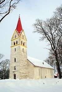
 Pärnu-Jaagupi church | |
 Flag  Coat of arms | |
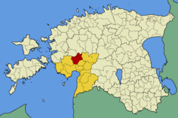
 Halinga Parish within Pärnu County. | |
| Country | |
| County | |
| Administrative centre | Pärnu-Jaagupi |
| Area | |
| • Total | 365 km2 (141 sq mi) |
| Population (01.01.2006) | |
| • Total | 3,492 |
| • Density | 9.6/km2 (25/sq mi) |
| Website | www.halingavald.ee |
Settlements
- Borough
- Villages
Aasa, Altküla, Anelema, Arase, Eametsa, Eense, Eerma, Enge, Ertsma, Halinga, Helenurme, Kablima, Kaelase, Kangru, Kodesmaa, Kuninga, Langerma, Lehtmetsa, Lehu, Libatse, Loomse, Maima, Mõisaküla, Mäeküla, Naartse, Oese, Pallika, Pereküla, Pitsalu, Pööravere, Roodi, Rukkiküla, Salu, Sepaküla, Sõõrike, Soosalu, Tarva, Tõrdu, Tühjasma, Vahenurme, Vakalepa, Valistre, Vee.
gollark: https://github.com/osmarks/random-stuff/tree/master/fractalart-rs - it is a carcinized haskell program
gollark: It's possible that you're quintopia. I haven't ruled it out.
gollark: As you can see, this is not the same.
gollark: https://discord.com/channels/800373244162867231/800373244162867234/829758646791176242
gollark: No, you're a different but similar image.
References
- Latitude.to. "Satellite map of Halinga Parish, Estonia. Latitude: 58.6167 Longitude: 24.5000". Latitude.to, maps, geolocated articles, latitude longitude coordinate conversion. Retrieved 2019-03-19.
- "Estonian Manors Portal - your guide to the world of manors". www.mois.ee. Retrieved 2019-03-19.
This article is issued from Wikipedia. The text is licensed under Creative Commons - Attribution - Sharealike. Additional terms may apply for the media files.