Hacienda Citincabchén
Hacienda Citincabchén is located in the Chapab Municipality in the state of Yucatán in southeastern Mexico. It is one of the properties that arose during the nineteenth century henequen boom.
Hacienda Citincabchén | |
|---|---|
Private Property / Tourist destination | |
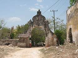 Entrance Hacienda Citincabchén, Yucatán. | |
Hacienda Citincabchén Location in Mexico | |
| Coordinates: 20°31′04″N 89°32′06″W | |
| Country | Mexico |
| Mexican States | Yucatán |
| Municipalities | Municipality of Chapab |
| Time zone | UTC−6 (CST) |
| • Summer (DST) | UTC−5 (CDT) |
| Postal code | 97857[1] |
| Area code | 997[2] |
Toponymy
The name (Citincabchén) is a word from the Mayan language meaning "I only like honey".[3] In 1910 the name changed from Citincabchén to Cituncabchén and then in 1921 to Citilcalchén, before changing to Citincabchén in 1930.
How to get there
The puebla, and hacienda are located halfway between Muna and Tekit approximately 68 km south of Mérida, Yucatán.
History
There was a henequen hacienda at the site which was part of a labor dispute heard in the 1916 Tribunals of the Revolution hearings under Governor Salvador Alvarado.[4]
Demographics
According to the 2005 census conducted by the INEGI, the population of the city was 817 inhabitants of whom were 423 men and 394 were women.[5]
| Year | 1900 | 1910 | 1921 | 1930 | 1940 | 1950 | 1960 | 1970 | 1980 | 1990 | 1995 | 2000 | 2005 |
|---|---|---|---|---|---|---|---|---|---|---|---|---|---|
| Population | 383 | 387 | 343 | 386 | 344 | 390 | 459 | 535 | 566 | 732 | 744 | 743 | 817 |
References
- "Consulta Códigos Postales". Servicio Postal Mexicano. Correos de México. Retrieved 29 April 2015.
- "Yucatan Mexico Telephone Area Codes". Travel Yucatan. Travel Yucatan. Retrieved 29 April 2015.
- "Citincabchén". Gobierno del Estado de Yucatán (in Spanish). Mérida, Mexico: Gobierno del Estado de Yucatán. Retrieved 8 May 2015.
- Blouin Jr., Francis X. (editor); Rosenberg, William G. (editor) (2005). Archives, Documentation, and Institutions of Social Memory: Essays from the Sawyer Seminar (1st pbk. ed.). Ann Arbor: University of Michigan Press. pp. 311–312. ISBN 978-0-472-11493-1. Retrieved 8 May 2015.CS1 maint: extra text: authors list (link)
- "Principales resultados por localidad (ITER)". Instituto Nacional de Estadística y Geografía (in Spanish). Instituto Nacional de Estadística y Geografía. 2010. Retrieved 30 April 2015.
Bibliography
- Bracamonte, P and Solís, R., Los espacios de autonomía maya, Ed. UADY, Mérida, 1997.
- Gobierno del Estado de Yucatán, "Los municipios de Yucatán", 1988.
- Kurjack, Edward y Silvia Garza, Atlas arqueológico del Estado de Yucatán, Ed. INAH, 1980.
- Patch, Robert, La formación de las estancias y haciendas en Yucatán durante la colonia, Ed. UADY, 1976.
- Peón Ancona, J. F., "Las antiguas haciendas de Yucatán", en Diario de Yucatán, Mérida, 1971.
Photo gallery
 Entry to main house Hacienda Citincabchén, Yucatán
.JPG) Main House, Hacienda Citincabchén, Yucatán
Main House, Hacienda Citincabchén, Yucatán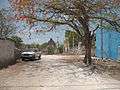 View of Hacienda Citincabchén, Yucatán
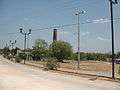 Chimney and henequen factory ruin Hacienda Citincabchén, Yucatán
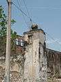
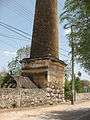 Chimney detail, Hacienda Citincabchén, Yucatán
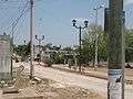 Henequen factory ruin, Hacienda Citincabchén, Yucatán
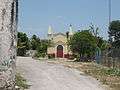 Chapel at Hacienda Citincabchén, Yucatán
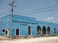 City Hall Citincabchén, Yucatán