Gunji, Uttarakhand
Gunji is a small village in Pithoragarh district in the northern state of Uttarakhand, India.[1] It is near the borders of Tibet and Nepal and the confluence of the Kuthi Yankti and Kalapani River, at the east end of the Kuthi Valley. It overlooks Mount Api in Nepal. The village is on the traditional Indian route to Kailas–Manasarovar.[2]
Gunji | |
|---|---|
Village | |
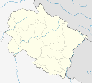 Gunji Location in Uttarakhand, India  Gunji Gunji (India) | |
| Coordinates: 30°10′46.2″N 80°51′27″E | |
| Country | |
| State | Uttarakhand |
| District | Pithoragarh |
| Area | |
| • Total | 189 km2 (73 sq mi) |
| Population (2011) | |
| • Total | 335 |
| • Density | 1.8/km2 (4.6/sq mi) |
| Languages | |
| • Official | Hindi |
| Time zone | UTC+5:30 (IST) |
| Vehicle registration | UK |
| Website | uk |
Demographics
As per the 2011 census, the village of Gunji has a population of 335 people living in 194 households.[1]
The village is only populated seasonally, with winters coming people migrate to lower places (mostly to Dharchula, in the same district).
Sashastra Seema Bal, the Indo-Tibet Border Police and GREF personnel remain there throughout the year.
Transportation
It is possible to reach Gunji by helicopter, which takes off from Dharchula.
While approaching Gunji from Dharcula and the rest of India, the route along the western bank of Sharda River (also called Mahakali River) at Gunji forks into two separate motorable routes, one goes north to Kailash-Mansarovar and another to the west to Adi Kailash.[3] In May 2020, India inaugurated a new 80 km long road from Dharchula via Gunji to Lipulekh Pass on India-China border [under geostrategic India-China Border Roads project] to the Kailas-Manasarovar.[4] In July 2020, India also opened a newly constructed road in this area from Gunji to Limpiyadhura Pass (Lampiya Dhura Pass on India-China border) which will reduce the trek time to Adi Kailash to two hours.[3]
Trekkers and other travelers may get food and accommodation here, but in order to reach Gunji one has to obtain an Inner line permit which is issued by SDM at Dharchula. Travellers need a valid ID, a health certificate and a character certificate at hand for this permit.
References
- Pithoragarh district census handbook, Director of Census Operations, Uttarakhand, 2011.
- Walton, H. G., ed. (1911), Almora: A Gazetteer, District Gazetteers of the United Provinces of Agra and Oudh, 35, Government Press, United Provinces, p. 229 – via archive.org
- Kalyan Das and BD Kasniyal, Road to Limpiyadhura will reduce Adi Kailash trek to two hours, Hindustan Times, 17 July 2020.
- Suhasini Haidar, New road to Kailash Mansarovar runs into diplomatic trouble, The Hindu, 9 May 2020.
Bibliography
- Atkinson, Edwin Thomas (1981) [first published 1884], The Himalayan Gazetteer, Volume 2, Part 2, Cosmo Publications – via archive.org
- Atkinson, Edwin Thomas (1981) [first published 1884], The Himalayan Gazetteer, Volume 3, Part 2, Cosmo Publications – via archive.org
- Chatterjee, Bishwa B. (January 1976), "The Bhotias of Uttarakhand", India International Centre Quarterly, 3 (1): 3–16, JSTOR 23001864
- Manzardo, Andrew E.; Dahal, Dilli Ram; Rai, Navin Kumar (1976), "The Byanshi: An ethnographic note on a trading group in far western Nepal" (PDF), INAS Journal, Institute of Nepal and Asian Studies, Tribhuvan University: 84–118, PMID 12311979
- Negi, R. S.; Singh, J.; Das, J. C. (1996), "Trade and Trade-Routes in the Cis and Trans Himalayas: Pattern of Traditional Entrepreneurship Among the Indian Highlanders", in Makhan Jha (ed.), The Himalayas: An Anthropological Perspective, M.D. Publications Pvt. Ltd., pp. 53–66, ISBN 978-81-7533-020-7
- Walton, H. G., ed. (1911), Almora: A Gazetteer, District Gazetteers of the United Provinces of Agra and Oudh, 35, Government Press, United Provinces – via archive.org