Guelile
Guelile (Arabic: جليل) is a town in southern Djibouti. It is situated about 107 kilometres (66 miles) southwest of Djibouti City and half a km south of the border with Ethiopia. It is the official border crossing into neighbouring Ethiopia by road and by rail. The area is served by a border post as well as by a train station at the Ethio-Djibouti Railways. Since 2016, it serves as the eastern terminus of the Ehio-Djibouti Railways and is the only remaining still operational train station along this railway in Djibouti. Guelile therefore serves as a commercial hub for the movement of goods to and from Djibouti City, Dire Dawa, Dewele, Ayesha and the surrounding area.
Guelile جليل | |
|---|---|
Town | |
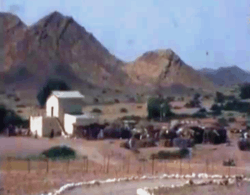 A photo of Guelile in 1977. | |
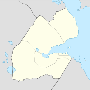 Guelile جليل Location in Djibouti | |
| Coordinates: 11°05′N 42°38′E | |
| Country | |
| Region | Ali Sabieh |
| Elevation | 810 m (2,660 ft) |
| Population | |
| • Total | 885 |
| Climate | BSh |
Overview
Guelile is located in a valley in the southern section of the country near the Ethiopian border. Guelile is located 10 km south of Ali Sabieh. The surrounding district is rich in both livestock and fledgeling agriculture. The town connects the capital Djibouti City to the northeast with Dire Dawa in Ethiopia to the southeast. Guelile is one of the oldest border crossing points along the Djibouti-Ethiopia border, and the nation's second largest inland port of entry.
Nearby towns and villages include Ali Sabieh (10 km), Dewele (7 km), Aysha (46 km) and Dire Dawa (218 km).
Demographics
As of 2019, the population of Guelile has been estimated to be 885. The town inhabitants belong to various mainly Afro-Asiatic-speaking ethnic groups, with the Issa Somali predominant.
Climate and geography
Guelile has a Semi-arid climate (BSh) in Köppen-Geiger system. Guelile generally features is warm winters and hot summers and is located at an altitude of 810 metres or 2,660 feet above sea level in low-shrouded mountains and hills. The average daytime temperatures during the summer months of June and August can rise to 35 °C (95 °F), with a low of 23 °C (73 °F) at night. The weather is cooler the rest of the year, averaging 25 °C (77 °F) during the day and 14 °C (57 °F) at nighttime.
| Climate data for Guelile | |||||||||||||
|---|---|---|---|---|---|---|---|---|---|---|---|---|---|
| Month | Jan | Feb | Mar | Apr | May | Jun | Jul | Aug | Sep | Oct | Nov | Dec | Year |
| Average high °C (°F) | 25.4 (77.7) |
26.2 (79.2) |
26.9 (80.4) |
27.3 (81.1) |
28.9 (84.0) |
33.0 (91.4) |
35.5 (95.9) |
34.2 (93.6) |
30.9 (87.6) |
27.1 (80.8) |
26.5 (79.7) |
25.7 (78.3) |
29.0 (84.1) |
| Average low °C (°F) | 14.2 (57.6) |
15.5 (59.9) |
16.6 (61.9) |
19.0 (66.2) |
21.5 (70.7) |
23.9 (75.0) |
23.6 (74.5) |
22.7 (72.9) |
21.4 (70.5) |
18.4 (65.1) |
16.1 (61.0) |
14.5 (58.1) |
19.0 (66.1) |
| Average rainfall mm (inches) | 16 (0.6) |
12 (0.5) |
18 (0.7) |
25 (1.0) |
11 (0.4) |
6 (0.2) |
25 (1.0) |
45 (1.8) |
34 (1.3) |
9 (0.4) |
12 (0.5) |
5 (0.2) |
218 (8.6) |
| Source: The Weather Channel | |||||||||||||