Gregory Terrace
Gregory Terrace is a road in Brisbane, Queensland, Australia.
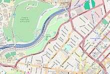
Open Street Map - Gregory Terrace, 2015
Geography
Gregory Terrace commences at an intersection with Wickham Terrace and College Road in Spring Hill (27.4608°S 153.0183°E). It travels in a north-easterly direction through Spring Hill, Fortitude Valley and Herston, where it terminates at a junction with Brookes Street (27.4498°S 153.0353°E).[1]
Landmarks
There are many landmarks along Gregory Terrace, including (from Spring Hill to Herston, sorted by street number/position):
- Roma Street Parkland
- 17: Cliveden Mansions
- 24: Brisbane Grammar School and its buildings
- Brisbane Girls Grammar School
- 285: St Joseph's College, Gregory Terrace
- 369: Victoria Flats
- 400: Centenary Pool Complex
- 449 & 451: Grangehill
- 454: Victoria Park
- 480: Old Museum Building
- 574: Brisbane Exhibition Ground
gollark: So the obvious solution is to save time and compile into it.
gollark: We are doing assembly programming in computer science and I dislike their language.
gollark: How quickly can a C compiler be written/retargeted for a bizarre architecture?
gollark: https://github.com/kelseyhightower/nocode
gollark: That's racist. Bee people have every right to consume product.
References
- "Gregory Terrace". Google Maps. Retrieved 9 January 2015.
External links
| Wikimedia Commons has media related to Gregory Terrace. |
This article is issued from Wikipedia. The text is licensed under Creative Commons - Attribution - Sharealike. Additional terms may apply for the media files.