Gregory Point
Gregory Point is a rocky point on the northwest coast of Smith Island in the South Shetland Islands, Antarctica projecting 700 m into Drake Passage. Situated 12.85 km west-southwest of Cape Smith, 3.9 km northwest of Mount Pisgah and 2 km north-northeast of Markeli Point. The point was roughly charted by Captain Henry Foster in 1829 and named Cape Gregory.

Location of Smith Island in the South Shetland Islands.

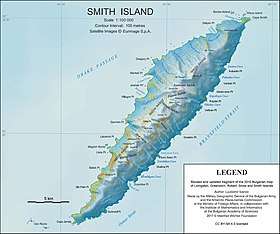
Topographic map of Smith Island.
Maps
- Chart of South Shetland including Coronation Island, &c. from the exploration of the sloop Dove in the years 1821 and 1822 by George Powell Commander of the same. Scale ca. 1:200000. London: Laurie, 1822.
- L.L. Ivanov. Antarctica: Livingston Island and Greenwich, Robert, Snow and Smith Islands. Scale 1:120000 topographic map. Troyan: Manfred Wörner Foundation, 2010. ISBN 978-954-92032-9-5 (First edition 2009. ISBN 978-954-92032-6-4)
- South Shetland Islands: Smith and Low Islands. Scale 1:150000 topographic map No. 13677. British Antarctic Survey, 2009.
- Antarctic Digital Database (ADD). Scale 1:250000 topographic map of Antarctica. Scientific Committee on Antarctic Research (SCAR). Since 1993, regularly upgraded and updated.
- L.L. Ivanov. Antarctica: Livingston Island and Smith Island. Scale 1:100000 topographic map. Manfred Wörner Foundation, 2017. ISBN 978-619-90008-3-0
gollark: SSH from CC would be impractical but also cool.
gollark: I personally find the packet thing more convenient, as just having a plain stream means you have to work out some way of delimiting packets and whatnot for everything.
gollark: I mean, for I/O, mostly?
gollark: Not just a raw bytestream.
gollark: You send and receive frames which have a size and stuff.
This article is issued from Wikipedia. The text is licensed under Creative Commons - Attribution - Sharealike. Additional terms may apply for the media files.