Green Lowther
Green Lowther is a hill in the Lowther Hills range, part of the Southern Uplands of Scotland. It is the highest point of the Lowther Hills and lies in Lanarkshire, east of the town of Sanquhar.
| Green Lowther | |
|---|---|
 | |
| Highest point | |
| Elevation | 732 m (2,402 ft) [1] |
| Prominence | 424 m (1,391 ft) [2] |
| Listing | Ma,Hu,Tu,Sim,G,D,DN,Y [3] |
| Coordinates | 55°23′24″N 3°44′15″W |
| Geography | |
| Location | South Lanarkshire, Scotland |
| Parent range | Lowther Hills, Southern Uplands |
| OS grid | NS 90037 12027 |
| Topo map | OS Landranger 71, 78 |
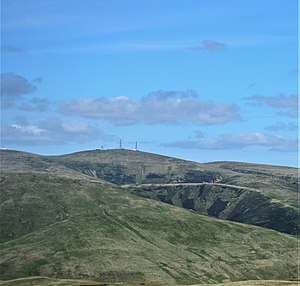
Despite the summit area being somewhat spoiled by the development of several masts which can be seen for many miles around, it still provides fantastic views across much of southern Scotland.[4]
Subsidiary SMC Summits
| Summit | Height (m) | Listing[5] |
|---|---|---|
| Cold Moss | 628 | Tu,Sim,DT,GT,DN[6] |
gollark: ... *how* large?
gollark: It's been done, I think.
gollark: Turbokrist is Java.
gollark: Evil idea: since Krist only lets the first private key work with an address, mine every possible address and slowly begin claiming them on the actual krist server.
gollark: Actually, your uwuing is visible on the discord bridge.
References
- "Green Lowther". hill-bagging.co.uk. Retrieved 28 October 2019.
- http://www.hill-bagging.co.uk/mountaindetails.php?qu=S&rf=1740
- http://www.hills-database.co.uk/database_notes.html#classification
- "Walkinghighlands Green Lowther". Walkinghighlands.co.uk. Retrieved 28 October 2019.
- http://www.hills-database.co.uk/database_notes.html#classification
- https://www.hill-bagging.co.uk/mountaindetails.php?qu=S&rf=1763
This article is issued from Wikipedia. The text is licensed under Creative Commons - Attribution - Sharealike. Additional terms may apply for the media files.