Great Alamance Creek
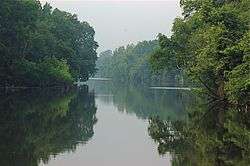
Great Alamance Creek, also called Big Alamance Creek, is a 37-mile long[5] creek that is a tributary of the Haw River. The creek's headwaters are in Guilford County, but it flows primarily through Alamance County, North Carolina. It is a major source of water for the cities of Burlington and Greensboro through the Lake Mackintosh Reservoir. It was called "Alamance" after an old local Native American word used to describe the blue-colored mud in the bottom of the creek.[6]
| Great Alamance Creek Tributary to Haw River | |
|---|---|
 Convergence of Great Alamance Creek and the Haw River in Swepsonville, North Carolina | |
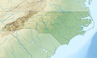
 Location of Great Alamance Creek mouth  Great Alamance Creek (the United States) | |
| Location | |
| Country | United States |
| State | North Carolina |
| Counties | Alamance Guilford |
| Physical characteristics | |
| Source | divide between Great Alamance Creek and Deep River |
| • location | about 1 mile north of Pleasant Garden, North Carolina |
| • coordinates | 35°58′40″N 079°44′57″W[1] |
| • elevation | 780 ft (240 m)[2] |
| Mouth | Haw River |
• location | Swepsonville, North Carolina[2] |
• coordinates | 36°01′02″N 079°21′57″W[1] |
• elevation | 458 ft (140 m)[2] |
| Length | 37.12 mi (59.74 km)[3] |
| Basin size | 262.23 square miles (679.2 km2)[4] |
| Discharge | |
| • location | Haw River |
| • average | 268.41 cu ft/s (7.601 m3/s) at mouth with Haw River[4] |
| Basin features | |
| Progression | northeast then east |
| River system | Haw River |
| Tributaries | |
| • left | Little Alamance Creek (Pleasant Garden Creek) Back Creek Little Alamance Creek |
| • right | Climax Creek Stinking Quarter Creek |
The creek was a part of the site of the Battle of Alamance, fought in 1771 between the colonial militia under the command of Governor William Tryon. When Alamance County was formed from Orange County in 1849, it was named for this battle and creek.
Great Alamance Creek has a tributary that is also called "Alamance Creek" - Little Alamance Creek, which is actually a little longer than Great Alamance Creek at over 12 miles,[5] much of it in Burlington. However, it has less water flow than Great Alamance Creek. Little Alamance Creek flows through City Park[7] in Burlington.
Variant names
According to the Geographic Names Information System, it has also been known historically as:[8]
- Alamance Creek
- Aramanchy River
- Aramancy River
- Big Alamance Creek
References
- "GNIS Detail - Big Alamance Creek". geonames.usgs.gov. US Geological Survey. Retrieved 28 July 2019.
- "Big Alamance Creek Topo Map, Alamance County NC (Mebane Area)". TopoZone. Locality, LLC. Retrieved 28 July 2019.
- "ArcGIS Web Application". epa.maps.arcgis.com. US EPA. Retrieved 28 July 2019.
- "Big Alamance Creek Report". Waters Geoviewer. US EPA. Retrieved 30 September 2019.
- Measurement Tool on Alamance County GIS found on the Alamance County Website
- http://www.alamance-nc.com/Alamance-NC/Our+Community/County+History.htm
- "Burlington, NC - Official Website - City Park". burlingtonnc.gov.
- "GNIS Detail - Big Alamance Creek". geonames.usgs.gov. US Geological Survey. Retrieved 10 October 2019.