Grade II listed buildings in the London Borough of Bexley
Grade II
| Name | Location | Type | Completed [note 1] | Date designated | Grid ref.[note 2] Geo-coordinates |
Entry number [note 3] | Image |
|---|---|---|---|---|---|---|---|
| 8 Upton Road | Bexleyheath | House | 17 December 1980 | 51°27′27″N 0°07′52″E | 1064205 |  | |
| 10 to 16 Burnt Oak Lane | Sidcup | House | 11 September 1985 | 51°26′14″N 0°06′05″E | 1359401 | 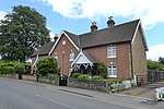 10 to 16 Burnt Oak Lane | |
| 25 and 27 Halfway Street | Sidcup | House | 17 December 1980 | 1188383 | .jpg) 25 and 27 Halfway Street | ||
| 33 and 35 Halfway Street | Sidcup | House | 17 December 1980 | 51°26′11″N 0°05′59″E | 1359412 | | |
| 152 and 154 North Cray Road | North Cray | House | 17 December 1980 | 51°25′49″N 0°08′21″E | 1064237 | | |
| King's Head | Bexley | Pub | 1 October 1953 | TQ4951373622 51°26′31″N 0°09′00″E |
1064244 | ||
| Royal Oak | Bexleyheath | Pub | 19th century | 17 December 1980 | TQ4783574818 51°27′09″N 0°07′40″E |
1064234 |
.jpg)
.jpg)
Notes
- The date given is the date used by Historic England as significant for the initial building or that of an important part in the structure's description.
- Sometimes known as OSGB36, the grid reference is based on the British national grid reference system used by the Ordnance Survey.
- The "List Entry Number" is a unique number assigned to each listed building and scheduled monument by Historic England.
gollark: It's apparently horribly toxic. And very dense.
gollark: > not constantly being on Discord
gollark: I read (well, skim) all messages in all the channels I have access to (except voice chat/bots) because I have waaaay too much free time right now.
gollark: That's more blueish. Turquoise, maybe.
gollark: The color corrected one looks pretty weird, I guess because it looks like you're not in water.
External links

This article is issued from Wikipedia. The text is licensed under Creative Commons - Attribution - Sharealike. Additional terms may apply for the media files.