Gorbea Natural Park
Gorbea Natural Park is a protected area that is located between the provinces of Alava and Vizcaya in the Basque Country (Spain), the largest Basque natural park with an area of 20,008 hectares (200.08 km2; 49,440 acres). It covers the municipalities of Areatza, Artea, Orozko, Zeberio,and Zeanuri in Vizcaya and Zigoitia, Zuia and Urkabustaiz in Álava. Gorbea Natural Park, along with the nearby natural park of Urkiola, form an important environmental unit. Natural Park was declared by the Basque Government Decree on 21 June 1994 with the purpose of protecting their natural heritage while promoting rural development, understanding and enjoyment. It takes its name from its highest peak, the Gorbea (Gorbeia or Gorbeiagane in Euskera) of 1,482 metres (4,862 ft). Other peaks of iinterest are Aldamin Peña of 1,373 metres (4,505 ft) and the Peñas de Itxina.

| Gorbea Natural Park | |
|---|---|
| Parque Natural del Gorbea Gorbeiako natura parkea | |
IUCN category V (protected landscape/seascape) | |
Gujuli's waterfall | |
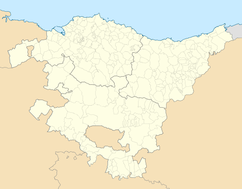
 Map of Spain  Gorbea Natural Park (Spain) | |
| Location | Alava and Vizcaya provinces Basque Country, Spain |
| Coordinates | 43.035°N 2.817°W[1] |
| Area | 20,008 hectares (49,440 acres) |
| Established | 1994 |
Communications and access to the park
Access to Gorbea Park is based on the national highway N-240 linking Bilbao to Vitoria, which surrounds the park to the east. To the west it is surrounded by the AP-68, which also links Bilbao and Vitoria and local roads, such as BI-2522 and A-624. The BI-3513 county of Orozco Artea] allows access to the north and the N -622 in the south. The bus service linking Bilbao and Vitoria, or Barazar Altube, is another means of access to the park.
Interpretive centers
There are two interpretation centres: one in the Alava, near the town of Sarria and another in the town of Villaro or Areatza in Vizcaya. There information can be found about the Natural Park as well as an exhibition that describes the characteristics of the park.
Mount Gorbea, the heart of the park
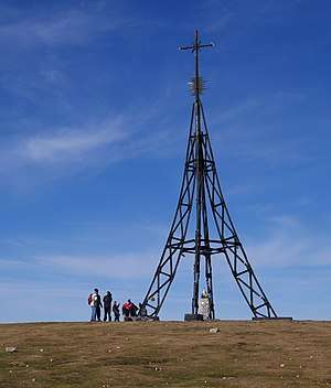
Gorbea Natural Park is formed around Mount Gorbea, and the peaks surrounding it. The summit of 1,482 m (4,862 ft) above sea level is a fundamental reference of the inhabitants of Alava and Vizcaya. For the Basques the Gorbea has been one of the mountains bocineros of which are calling for General Meetings. The summit of the mountain is surmounted by a cross of 18 m (59 ft) in height (the first that was installed was 33.33 m (109.4 ft) and the second 22 m (72 ft)) installed in the early twentieth century and has become a symbol for all Basques coming to form part of popular culture.

Climate
The altitude of Gorbea Natural Park gives it a typical mountain climate, and acts as a major barrier to stop the wet winds from the Gulf of Biscay, with substantive differences between the northern, more humid, and the south, dry and sunny. Rainfall is abundant, present in all months of the year, although the fall and winter months are the rainy seasons. In general, are higher than 1,300 mm (51 in) / year in the northern slope, which may exceed 2,000 mm (79 in) in the summit. On the south side down to about rainfall about 1,000 mm (39 in) / year. The average annual temperature between 12 °C (54 °F) in the valleys Basques to 8 °C (46 °F) in higher areas. Precipitation in these latter areas is in the form of snow during the winter months, which remains until early spring. The difference in precipitation and temperatures between the area of Vizcaya and Alava are evident in various aspects such as flora or geology. Due to the effect more of the abundant rains are in the northern part of the massif and the southern part is characterized by a climate of Continental influence.
Geology and geomorphology
Geologically Gorbeia is mostly composed of sedimentary rocks. They have been created by erosion processes whose sediments were transported inland sea and then lithified (the process by which sediments are transformed into a compact rock.) . The park is known for its rocky surroundings. Formations as the Eye of Atxular or Atxular Itxina in karst and the cave in Álava Mairuelegorreta accidents are the most notable.
In the park there are two types of substrates: Silica forms of landscape originates rounded, dark tones and lush vegetation. Gorbea summit is a good example.
Limestone: light-colored surfaces and rocky, limestone areas are characterized by the presence of cracks, potholes and depressions. There are 500 chambers listed in the Park, of which the cave and Supelegor Mairuelegorreta are most popular. In the limestone karst highlight Itxina complex, which evolved over Urgonian extracts (characteristics of the limestone) that have caused one of the best examples of forms of Euskal Herria kartice.
The hydrography of Gorbea, which pours into the Mediterranean and Cantabrian consists of small rivers that should save a significant gap forming gullies and ravines. In the Mediterranean, which run to Álava, there is the Zubialde Bayas River, in the Cantabrian Altube, Arnuari, and Arratia Zeberio.
Flora and fauna
With regard to vegetation, the area holds important deciduous forests, especially in the aspect of Alava (Altube area). The tree that occupies the largest area with about 6,000 have been, but we also found robledades sessile oak and pedunculate oak, and sketches of Cantabrian holm oak and strawberry trees reveal that centuries ago the climate was much warmer. Alders, willows, ash, and poplars are increasingly rare riparian forests found to shelter species of great interest. The conifers, mostly exotic species planted for forestry, occupy much of the Park's area, among the most representative of these plantations are insignis and radiata pine (Pinus radiata), Lawson cypress and the black pine (Pinus nigra).
Excessive logging that occurred since the eighteenth century intended for work in the foundries, shipbuilding and papermaking even led to the provincial council to decree that the repopulation of the cleared areas, would be done with commercial species.
There is a large representation of species of fauna, forest raptors (hawk, hawk, eagle toed) and rupícolas (peregrine falcon, Egyptian vulture), mammals (bobcat, deer, polecats, martens, marten and dormouse). The ponds and wetlands are home to a good representation of amphibians (Alpine newt and frog agile). Carrion vultures have the Park as part of its territory but do not nest in it, they come from the nearby Parque Natural de la Sierra Urkiola and Saved and Valderejo Natural Park.
Places to visit
_AGA7421.jpg)
There are many landscapes that are worth visiting, but the best known are: Cruz del Gorbea, Itxina Karst, The meadows of Araba, Mairuelegorreta cave, waterfall and wetland Gujuli Saldropo, Otzarreta forest.
Population
In the park there are no inhabited areas but there is a scattered population living in villages, there is a seasonal population, pastoralists, living in shacks during pasture season. The small towns surrounding the park are home to some 9,000 people and its economy is founded on farms, herds of latxa sheep, cattle and horses, and forestry. Subsistence agriculture is the sale of surplus in the markets of the regions concerned.
Population history of the occupation
The first humans of which there is evidence in the park territories date back to 100,000 years before Christ, in the Middle Paleolithic, five teeth of a Neanderthal have been found and identified. No evidence was found for the occupation of cromangones and is believed to be due to harsh weather in the Upper Paleolithic period in the cave. Similar Arrillor lithic remains of Magdalenian type in the cave were found relating to Bolinkoba piety, antlers and bones with geometric prints. Mesolithic finds in the cave there Urratxa III belonging to the so-called culture Azilian. They built the largest Neolithic stone monuments, normally for funerary use. The dolmens and barrows are easy to observe structures within the park. More than 10 dolmens and burial mounds are located in the current grazing areas.
The isolation of these territories means the influence of historical movements have been minimal. The life forms of Neolithic pastoralism have remained unchanged to the present. Only the occupation of some isolated settlements of farmers has allowed a change in the historical record. This has favored the conservation delentorno with the values that have and are currently protected.
Unlike neighboring Urquiola Natural Park, which has historically been an important route of communication, Gorbea has remained outside, keeping the traditional ways of life until the advent of technological revolutions succeeded in making a dent in them. Therefore, traditional buildings, such as water mills, predator, refrigerators and evidence of the coal industry are now beautifully preserved, one of its main actrativos, along with the natural course.
The main activity that has historically been developed in the territories that make up the park is grazing. This activity was completed by the manufacture of lime, by firing limestone kilns, charcoal making and the manufacture of ice in a refrigerator. Of these the only activity that remains is that of grazing, and the remains of its other facilities are used to develop a new source of wealth for the area, urban tourism. Gorbea Natural Park has become a place to which people flock from nearby urban areas, especially in Bilbao and Vitoria, for sports and leisure activities. In the park there are about 13 chapels, the most important of which is the shrine of Our Lady of the Snows. During the mid-twentieth century Club Deportivo de Bilbao Egiriñao built a shelter.
In an area like the land surrounding the Gorbea, where outside influences have been reluctant to enter, the mythology has been kept alive in its residents. There is the main goddess Mari, the Lady of Anboto, whose house is seen from many parts of the park, and the forests are inhabited by the Basajaun and on the banks of the river, the ladies with flippers, the Lamiak.
References
- "Gorbea Nature Park". protectedplanet.net.
- "Gorbea Nature Park". protectedplanet.net.
External links
| Wikimedia Commons has media related to Gorbeia Natural Park. |