Gopło
Gopło [ˈɡɔpwɔ] is a lake in Kuyavian-Pomeranian Voivodeship, north-central Poland, near the city of Gniezno. It gives its name to the protected area called Gopło Landscape Park.
| Gopło | |
|---|---|
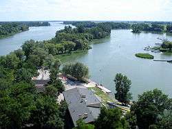 view from the Mouse Tower of Kruszwica | |
| Location | Kuyavian-Pomeranian Voivodeship |
| Coordinates | 52°35′08″N 18°21′15″E |
| Primary inflows | Noteć |
| Primary outflows | Noteć |
| Basin countries | Poland |
| Max. length | 25 km (16 mi) |
| Max. width | 3.5 km (2.2 mi) |
| Surface area | 21.8 km2 (8.4 sq mi) |
| Average depth | 4.7 m (15 ft) |
| Max. depth | 16.6 m (54 ft) |
| Surface elevation | 77 m (253 ft) |
In early Middle Ages, the shores of Lake Gopło were home to a West Slavic tribe of Goplans. At the northern end of the lake stands the "Mouse Tower" of Kruszwica. Its name derives from a legend of the corrupt Prince Popiel, who fled to the tower from his rebelling population, and was devoured there by mice. Some historians and archaeologists consider the area the heart of the first state of the Polans, the "founding" tribe of Poland.[1]
Notes
- Lozny, "Transition to Statehood", p. 283.
gollark: I'll pay you 823 kilobees to do their thing.
gollark: Clearly they want help with AsmBB.
gollark: Wow, lsblk DEFINITELY WORKS for this task, so it is a GOOD IDEA to use it.
gollark: Oh yes, I do sometimes play df when I need to know how much disk space I have left.
gollark: CSS is very !!FUN!! because there are 172489162846918247128947189701911911010101110101010101 ways to do things which seem like they ought to make sense, except only 1 works.
References
- Lozny, Ludomir (2004), "The Transition to Statehood in Central Europe", in Grinin, Leonid E, et al. (eds.), The Early State, Its Alternatives and Analogues, Saratov: Uchitel Publishing House, ISBN 5-7057-0547-6, pp. 278–87
This article is issued from Wikipedia. The text is licensed under Creative Commons - Attribution - Sharealike. Additional terms may apply for the media files.