Gold Mountain (Washington)
Gold Mountain is a 1,761-foot (537 m) summit in the Blue Hills on the Kitsap Peninsula of Washington state, in the United States' Pacific Northwest. It is the highest point on the Kitsap Peninsula and the highest point in Kitsap County, Washington,[1] and nearby 1,639-foot (500 m) Green Mountain is the second-highest point.[2]
| Gold Mountain | |
|---|---|
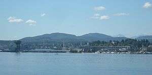
 Gold Mountain behind the Puget Sound Naval Shipyard in Bremerton | |
| Highest point | |
| Elevation | 1,761 feet (537 m) |
| Coordinates | 47°32′56″N 122°47′13″W |
| Geography | |
| Location | Kitsap County, Washington, United States |
| Parent range | Blue Hills |
| Topo map | USGS Bremerton West |
The mountain lies partly on private land, partly in the City of Bremerton watershed inaccessible to the general public, and partly in the adjacent 6,000-acre (2,400 ha) Green Mountain State Forest which is open to hikers, horses, and on- and off-road vehicles.[2]
Most of the eastern half of Gold Mountain is in the city watershed, with the Union River reservoir at the foot. The summit itself is in a quarter quarter section exclave of the state forest, connected at a corner.[3] The summit is about 660 feet (200 m) outside the city limits, six miles (9.7 km) west of downtown Bremerton.[4]
Radio and television transmitters
The mountain summit has an antenna farm including transmitters for Kitsap Peninsula area emergency services,[5] as well as Seattle television and radio stations KCPQ (Fox 13),[6] KTBW and KYFQ. Since 1981, the Western Washington Repeater Association has operated an amateur radio repeater, call sign WW7RA, on the site,[7] with coverage throughout the Puget Sound region from Centralia to Bellingham.[8][9]
A Continuously Operating Reference Station used for GPS-based geodesy is located at the KTBW site on the summit.[10]
References
- "Kitsap county". Lakes of Washington, Volume 1: Water Supply Bulletin 14 (PDF). Washington State Department of Ecology. 1973. p. 203.
- Andrew Weber, Bryce Stevens (2010), 60 Hikes Within 60 Miles: Seattle: Including Bellevue, Everett, and Tacoma, Menasha Ridge Press, p. 176, ISBN 9780897328128CS1 maint: uses authors parameter (link)
- Green Mountain State Forest trail system map (PDF), Washington Department of Natural Resources, 2009, retrieved 2012-02-17
- Bremerton city limits map, City of Bremerton Public Records & Information Center, archived from the original on 2014-10-11, retrieved 2014-09-28
- "Outage Hits Kitsap County", The Seattle Times, June 30, 1995
- About us, Fox13 (KCPQ), retrieved 2013-02-17
- WWRA history (PDF), Western Washington Repeater Association, February 6, 2008, retrieved 2012-02-17
- WW7RA propagation map, K5EHX amateur (ham) radio repeater database, retrieved 2013-02-17
- Peter Policani, K7PP, THE NEW K7PP REPEATER NETWORK, archived from the original on 2013-04-24, retrieved 2013-02-18
- Pacific Northwest Geodetic Array—Gold Hill (sic) Kitsap, Central Washington University geology department, retrieved 2013-02-17
External links
| Wikimedia Commons has media related to Gold Mountain. |
- U.S. Geological Survey Geographic Names Information System: Gold Mountain (summit) (1979 entry)
- U.S. Geological Survey Geographic Names Information System: Gold Mountain Lookout (1992 entry)
- Green Mountain State Forest, Washington State Department of Natural Resources
- Hike of the Week: Green Mountain, The Olympian (2011)
- Plans for Green Mountain, Tahuya state forests almost done, Kitsap Sun (2012)