Glogghüs
The Glogghüs is a mountain of the Urner Alps, located on the border between the Swiss cantons of Obwalden and Bern. On its northern side it overlooks the Melchsee and the village of Melchsee-Frutt.
| Glogghüs | |
|---|---|
 Glogghüs (right) | |
| Highest point | |
| Elevation | 2,534 m (8,314 ft) |
| Prominence | 554 m (1,818 ft) [1] |
| Listing | Alpine mountains 2500-2999 m |
| Coordinates | 46°45′50.8″N 08°15′31″E |
| Geography | |
 Glogghüs Location in Switzerland | |
| Location | Obwalden/Bern, Switzerland |
| Parent range | Urner Alps |
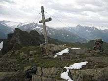
Summit of Glogghüs
Its elongated summit also represents the border between the municipalities of Kerns (Canton of Obwalden) and Hasliberg (Canton of Bern).
References
- Retrieved from the Swisstopo topographic maps and Google Earth. The key col is located east of the Tannensee at 1,980 metres.
This article is issued from Wikipedia. The text is licensed under Creative Commons - Attribution - Sharealike. Additional terms may apply for the media files.