Georgia State Route 352
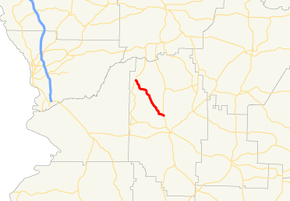
State Route 352 (SR 352) is a 9.8-mile-long (15.8 km) southeast-to-northwest state highway in northwestern Marion County in the west-central part of the U.S. state of Georgia. Its entire length is located just to the east of Fort Benning.
| ||||
|---|---|---|---|---|
 | ||||
| Route information | ||||
| Maintained by GDOT | ||||
| Length | 9.8 mi[1] (15.8 km) | |||
| Existed | 1963[2][3]–present | |||
| Major junctions | ||||
| South end | ||||
| North end | ||||
| Location | ||||
| Counties | Marion | |||
| Highway system | ||||
| ||||

Route description
SR 352 begins at an intersection with SR 41 north-northwest of Buena Vista, just to the east of Brantley. The highway travels to the northwest through generally rural parts of the county, until it meets its northern terminus, an intersection with SR 355 south-southwest of the community of Juniper.[1]
History
SR 352 was built along its current alignment between 1960 and 1963.[2][3] By 1966, the entire length of road was paved.[3][4]
Major intersections
The entire route is in Marion County.
| Location | mi[1] | km | Destinations | Notes | |
|---|---|---|---|---|---|
| | 0.0 | 0.0 | Southern terminus | ||
| | 9.8 | 15.8 | Northern terminus | ||
| 1.000 mi = 1.609 km; 1.000 km = 0.621 mi | |||||
gollark: <@!714406501346967572> 0.4 offense, but if you could easily prove the Collatz conjecture with relatively simple maths someone already would have,
gollark: I assume the 0/1/infinite solution thing is from something something linear algebra.
gollark: Ah. So the matrix maps the values of all the variables to the outputs of each equation, and the same output can be attained in multiple ways sometimes.
gollark: No, I mean how do you use that to get intuition for number of solutions of some equations.
gollark: I've seen it with intersecting lines/planes(/hyperplanes), how does it work to interpret it as a transformation?
See also
.svg.png)

References
- Google (November 3, 2013). "Route of SR 352" (Map). Google Maps. Google. Retrieved November 3, 2013.
- Georgia State Highway System (PDF) (Map). Cartography by GSHD. Georgia State Highway Department. June 1, 1960. Archived from the original (PDF) on December 22, 2015. Retrieved August 16, 2015.
- Georgia State Highway System (PDF) (Map). Cartography by GSHD. Georgia State Highway Department. June 1, 1963. Retrieved August 16, 2015.
- Georgia State Highway System (PDF) (Map). Cartography by GSHD. Georgia State Highway Department. January 1, 1966. Retrieved August 16, 2015.
External links
This article is issued from Wikipedia. The text is licensed under Creative Commons - Attribution - Sharealike. Additional terms may apply for the media files.