Georgia State Route 311
State Route 311 (SR 311) is a north-south state highway located in the southwest part of the U.S. state of Georgia.
| ||||
|---|---|---|---|---|
 | ||||
| Route information | ||||
| Maintained by GDOT | ||||
| Length | 23.9 mi[1] (38.5 km) | |||
| Major junctions | ||||
| South end | ||||
| North end | ||||
| Location | ||||
| Counties | Decatur, Mitchell | |||
| Highway system | ||||
| ||||

Route description
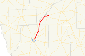
SR 311 begins at an intersection with SR 97/SR 309 in Bainbridge. The route heads northeast through rural parts of Decatur County before entering Mitchell County. Farther to the northeast, SR 311 intersects SR 65 west of Hopeful. SR 311 curves around Hopeful until it meets its northern terminus, an intersection with SR 97 just northeast of Hopeful.
History
Major intersections
| County | Location | mi[1] | km | Destinations | Notes |
|---|---|---|---|---|---|
| Decatur | Bainbridge | 0.0 | 0.0 | Southern terminus | |
| Mitchell | | 20.3 | 32.7 | ||
| | 23.9 | 38.5 | Northern terminus | ||
| 1.000 mi = 1.609 km; 1.000 km = 0.621 mi | |||||
gollark: Not ALWAYS.
gollark: I mean, it's not too eldritch all the time.
gollark: You could... learn... CSS?
gollark: <@!356107472269869058> So why not just improve the styling and add some links?
gollark: In my new architecture, all values carry an extra endianness tag, for maximum !!FUN!!.
See also
.svg.png)

References
- Google (February 6, 2013). "Route of SR 311" (Map). Google Maps. Google. Retrieved February 6, 2013.
External links
This article is issued from Wikipedia. The text is licensed under Creative Commons - Attribution - Sharealike. Additional terms may apply for the media files.