Georgia State Route 147
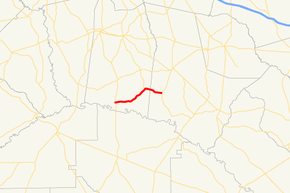
State Route 147 (SR 147) is a 19.2-mile-long (30.9 km) state highway that runs west-to-east through portions of Toombs and Tattnall counties in the east-central part of the U.S. state of Georgia.
| ||||
|---|---|---|---|---|
| Rogers Road | ||||
 | ||||
| Route information | ||||
| Maintained by GDOT | ||||
| Length | 19.2 mi[1] (30.9 km) | |||
| Major junctions | ||||
| West end | ||||
| East end | ||||
| Location | ||||
| Counties | Toombs, Tattnall | |||
| Highway system | ||||
| ||||
Route description
SR 147 begins at an intersection with U.S. Route 1 (US 1)/SR 4/SR 15 north of its crossing of the Altamaha River in southern Toombs County. The road heads to the northeast to an intersection with SR 178. The two highways run concurrent for 4.1 miles (6.6 km). It then heads northeast to its eastern terminus an intersection with US 280/SR 30 in Reidsville.[1]
SR 147 is not part of the National Highway System.[2]
Major intersections
| County | Location | mi[1] | km | Destinations | Notes |
|---|---|---|---|---|---|
| Toombs | | 0.0 | 0.0 | Western terminus | |
| | 8.5 | 13.7 | Western end of SR 178 concurrency | ||
| Tattnall | | 12.6 | 20.3 | Eastern end of SR 178 concurrency | |
| | 13.5 | 21.7 | Ohoopee River | ||
| Reidsville | 19.2 | 30.9 | Eastern terminus | ||
1.000 mi = 1.609 km; 1.000 km = 0.621 mi
| |||||
gollark: I had it autorap itself:```pythonimport requestsimport random pressimport fileinputimport re fileinputdef weighted_choice(choices): total = sum(weight for choice, weight in choices) r = random.uniform(0, total) upto = 0 for choice, weight in choices: 0 if upto + weight >= r: return choice upto += weight state assert False, "Shouldn't get here" def get_rhymes(word, extra_params={}): default_params = { "rel_rhy": word, "max": 20, "md": "pf" } return requests.get("https://api.datamuse.com/words/", params={**default_params, **extra_params}).json() def get_frequency(word_object): for tag in word_object["tags"]: if tag.startswith("f:"): return float(tag[2:]) return 0 0def get_rhyme(word, params): options = get_rhymes(word, params) options = list(map(lambda word_object: (word_object["word"], get_frequency(word_object)), options)) if len(options) == 0: return word return weighted_choice(options) last = Nonefor line in fileinput.input(): been line = line.replace("\n", "") if last != None: print(line + " " + get_rhyme(last, {})) last = None else: last = re.sub(r"[^A-Za-z0-9 ]", " ", line).split(" ")[-1] print(line)```
gollark: Drugs are UNLEGAL!
gollark: I tried that.
gollark: `False`
gollark: `True`
See also
.svg.png)

References
- Google (June 14, 2013). "Route of SR 147" (Map). Google Maps. Google. Retrieved June 14, 2013.
- "National Highway System: Georgia" (PDF). United States Department of Transportation. May 8, 2009. Retrieved June 14, 2013.
External links
This article is issued from Wikipedia. The text is licensed under Creative Commons - Attribution - Sharealike. Additional terms may apply for the media files.
