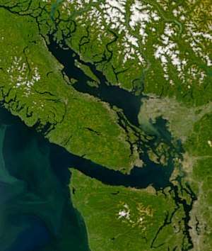
Georgia Depression
The Georgia Depression is a landform and ecoregion in the Pacific Northwest which is part of the larger Insular Mountain System of the North American Cordillera. The depression includes the lowland regions of southwestern British Columbia and northwestern Washington.

Description
The Georgia Depression is encompassed by the Pacific Ranges to the north, Vancouver Island Ranges and Olympic Mountains to the west, and North Cascades to the east. The depression itself includes the Fraser Lowland, Nanaimo and Nahwitti lowlands of Vancouver Island, Puget Sound basin, and all the islands and adjoining waterways of the Salish Sea.[1]
Much of the Georgia Depression is dry, flat, and at low elevation relative to the surrounding highlands. As such, a wide diversity of flora and fauna thrive within the depression.[2]
The majority of the population of British Columbia and Washington reside within this depression. Human activity has greatly altered much of the natural environment here through industrialization, agriculture, forestry, urbanization, and suburban sprawl.
References
- "BC Breeding Bird Atlas". Retrieved 2019-09-19.
- "Georgia Depression". Sierra Club BC. Retrieved 2019-09-19.
- Landforms of British Columbia: A Physiographic Outline, by S. Holland 1964 (revised 1976), British Columbia Ministry of Energy, Mines and Petroleum Resources
- Landforms of British Columbia: A Physiographic Outline- Physiographic map, by S. Holland 1964 (revised 1976), British Columbia Ministry of Energy, Mines and Petroleum Resources
- access to online Physiographic map of the Canadian Cordillera, W.H. Mathews, Geophysical Survey of Canada (Natural Resources Canada), 1986