Gayhata Union
Gayhata Union (Bengali: গয়হাটা ইউনিয়ন) is a union of Nagarpur Upazila, Tangail District, Bangladesh. It is situated 3 km west of Nagarpur and 27 km south of Tangail city.
Gayhata Union গয়হাটা ইউনিয়ন | |
|---|---|
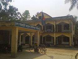 Gayhata Union Parishad Complex | |
 Gayhata Union Location of Gayhata Union in Bangladesh | |
| Coordinates: 24.06814456151135°N 89.83941614627838°E | |
| Country | Bangladesh |
| Division | Dhaka Division |
| District | Tangail District |
| Upazila | Nagarpur Upazila |
| Established on | 1984 |
| Government | |
| • Type | Union Council |
| • Chairman | Md Mostafizur Rahman Askor |
| Area | |
| • Total | 25.28 km2 (9.76 sq mi) |
| Elevation | 14 m (46 ft) |
| Population (2011) | |
| • Total | 30,613 |
| • Density | 1,200/km2 (3,100/sq mi) |
| Time zone | UTC+6 (BST) |
| Postal code | 1936 |
| Website | gayhataup |
Demographics
According to Population Census 2011 performed by Bangladesh Bureau of Statistics, The total population of Gayhata union is 30,613. There are 6,830 households in total.[1]
Education
The literacy rate of Gayhata Union is 48.1% (Male-50.4%, Female-45.9%).[2]
gollark: What video?
gollark: Bee is a full-time occupation.
gollark: Yes, with bee.
gollark: We'll process them in 6 to 8 business weeks.
gollark: I'm busy.
See also
- Union Councils of Tangail District
References
- "Tangail Table C-01 : Area, Households, Population, Density by Residence and Community" (PDF). bbs.gov.bd. Archived from the original (PDF) on 2014-11-13. Retrieved 2016-03-01.
- "Tangail : C06 : Distribution of Population aged 7 years and above by Literacy, Sex, Residence and Community" (PDF). bbs.gov.bd. Archived from the original (PDF) on 2014-11-13. Retrieved 2016-02-25.
This article is issued from Wikipedia. The text is licensed under Creative Commons - Attribution - Sharealike. Additional terms may apply for the media files.