Galgenberg (Elbingerode)
The Galgenberg is a 506.1-metre-high hill[1] east of Elbingerode (Harz) in the Harz Mountains of central Germany. It marks the highest point on the row of limestone crags found there. The old Trock Way (Trockweg), which ran from Quedlinburg to the imperial stronghold of Bodfeld, probably ran past the Galgenberg immediately to the north. East of the hill lies the abandoned village of Erdfelde that was closely linked to Bodfeld.
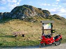
The Galgenberg from the north
History
As the name of the hill suggests, this spot is the old execution site of the town of Elbingerode, on which the gallows stood where many thieves were hanged.
Walking
The Galgenberg is No. 38 in the network of hiking checkpoints in the Harzer Wandernadel.[2]
gollark: The bump allocator is just rebranded osmarksmalloc™.
gollark: Slightly unoptimized and buggy hash tables, linked lists even though they're generally awful datastructures because they're easy to implement, actually I can't think of other instances immediately.
gollark: This sort of attitude leads to mildly worse code everywhere.
gollark: Doesn't C have some `hcreate` thing?
gollark: osmarkslispFPGA™ when?!
References
- Map services of the Federal Agency for Nature Conservation
- Harzer Wandernadel: Stempelstelle 38 – Galgenberg Archived 2016-02-25 at the Wayback Machine at harzer-wandernadel.de
This article is issued from Wikipedia. The text is licensed under Creative Commons - Attribution - Sharealike. Additional terms may apply for the media files.