Güneli, Nusaybin
Güneli (Kurdish: Geliyê Sora)[1] is a former Yazidi village located in the Nusaybin district of the Mardin Province in southeastern Turkey. The village is located ca. 30 kilometres (19 mi) northeast of Nusaybin in the Tur Abdin region of southeastern Anatolia.[2][3]
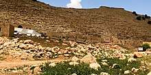
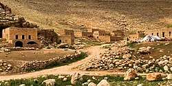
View of Güneli (2018)
Güneli Geliyê Sora | |
|---|---|
Village | |
 | |
 Güneli Location in Turkey | |
| Coordinates: 37°08′52″N 41°31′26″E | |
| Country | |
| Province | Mardin |
| District | Nusaybin |
| Post code | 47300 |
Location
Güneli is located ca. 4 kilometres (2.5 mi) northwest of the Yazidi village Mezre and ca. 3.5 kilometres (2.2 mi) northwest of the Yazidi village Khanik. The Yazidi cemetery Goristana Hesen Begê is located ca. 2.5 kilometres (1.6 mi) in the southeast.
gollark: That does not mean what you seem to think it means.
gollark: "Dimensions"?
gollark: Whaaaa?
gollark: Can you prove the existence of multiverses?
gollark: Instead of creating the universes, maybe just simulate some with intelligent life?
References
- İbrahim Sediyani (2009). Adını arayan coğrafya. Özedönüş Yayınları. p. 255. ISBN 9786054296002.
- Kreyenbroek, Philip G. (2009). Yezidism in Europe: Different Generations Speak about Their Religion. Otto Harrassowitz Verlag. ISBN 9783447060608.
- "Index Anatolicus". nisanyanmap.com. Retrieved 2018-12-28.
This article is issued from Wikipedia. The text is licensed under Creative Commons - Attribution - Sharealike. Additional terms may apply for the media files.