Gélise
The Gélise (pronounced [ʒeliːz]) is a tributary of the Baïse River in Gascony, southwestern France.
| Gélise | |
|---|---|
 | |
| Location | |
| Country | France |
| Physical characteristics | |
| Mouth | |
• location | Baïse |
• coordinates | 44°10′45″N 0°17′18″E |
| Length | 92 km (57 mi) |
| Basin features | |
| Progression | Baïse→ Garonne→ Gironde estuary→ Atlantic Ocean |
Etymology
The name Gélise comes from the Aquitanian hydronymic root Jel, meaning "watercourse."
Geography
The Gélise originates in the Gers département at Cahuzères, north of Lupiac, then it flows northwest in the direction of Eauze. It drains the land around Castelnau-d'Auzan, then it flows northeast where it forms the natural boundary between the forest of the Landes of Gascony, the slopes of the Armagnac-Ténarèze.
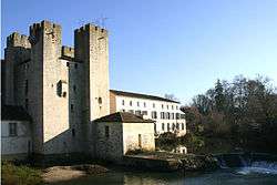
It unites with the Baïse just after passing the fortified mill of Lavardac in Lot-et-Garonne.
The Osse, a right tributary, joins the Gélise near Nérac. The Auzoue, a right tributary, joins the Gélise at Mézin. The Izaute, a right tributary, joins the Gélise at Saint-Pé-Saint-Simon.
Départements and principal cities
The Gélise passes through the following départements and cities:
References