French Meadows Reservoir
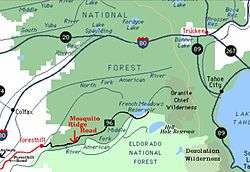
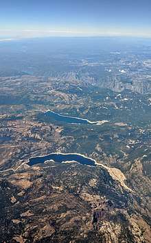
French Meadows Reservoir is a manmade lake 36 miles (58 km) northeast of Foresthill, California, United States on the Middle Fork of the American River. The reservoir is 2.9 miles (4.7 km) long, 0.6-mile (0.97 km) wide, with 7.3 miles (11.7 km) of shoreline.
| French Meadows Reservoir | |
|---|---|
 Map of area around reservoir | |
| Location | Placer County, California |
| Coordinates | 39°06′42″N 120°28′06″W |
| Primary inflows | North Fork American River |
| Basin countries | United States |
| Max. length | 2.9 mi (4.7 km) |
| Max. width | 0.6 mi (0.97 km) |
| Water volume | 125,601 acre⋅ft (154,927,000 m3) |
| Shore length1 | 7.3 mi (11.7 km) |
| Surface elevation | 5,263 ft (1,604 m) |
| 1 Shore length is not a well-defined measure. | |
Tahoe National Forest manages the recreational facilities which include five campgrounds, two group campgrounds and two paved boat launch ramps. Activities at the lake include powerboating, kayaking, canoeing, fishing, picnicking and hiking. The reservoir is entirely within a state game refuge so no firearms, pellet guns or archery weapons are allowed.
The elevation of the lake is 5,263 feet (1,604 m), and it is nine miles (14 km) from the crest of the Sierra Nevada Mountain Range.[1]
The California Office of Environmental Health Hazard Assessment (OEHHA) has developed a safe eating advisory for French Meadows Reservoir based on levels of mercury found in fish caught here.[2]
History
The reservoir was built in December 1964 with the construction on the Middle Fork of the American River of the L.L. Anderson Dam. The dam is rock-fill with earth core. The capacity of the reservoir is 125,601 acre feet (154,927,000 m3) of water. French Meadows Reservoir is part of the Middle Fork Project for hydroelectric power generation and most of its water is diverted to the French Meadows Powerhouse, located along the north shore of Hell Hole Reservoir, by a tunnel. Releases from French Meadows Reservoir to the powerhouse began one year later, December 13, 1965. A minimal "fish flow" is released into the natural waterway of the Middle Fork of the American River for fish and wildlife habitat considerations. The project is operated by the Placer County Water Agency.[3]
See also
- List of dams and reservoirs in California
- List of lakes in California
Footnotes
- Pike, Charles Paddling Northern California, The Globe Pequot Press, 2001
- Admin, OEHHA (2014-12-30). "Folsom Lake". OEHHA. Retrieved 2018-06-12.
- The 1999 California Hydrologic Data Report USGS retrieved 13 March 2008