Foyn Point

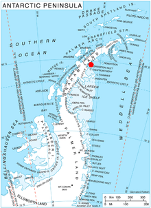
Foyn Point (65°15′S 61°38′W) is a point surmounted by a peak 525 metres (1,720 ft) high, forming the southeast extremity of Blagoevgrad Peninsula and marking the north side of the entrance to Exasperation Inlet, on Oscar II Coast on the east side of Graham Land, Antarctica. Sir Hubert Wilkins on a flight of December 20, 1928 photographed what appeared to be an island off the east coast, later charting it in 66°30′S 62°30′W (present Slav Point). Subsequent comparison of Wilkins' photographs of this feature with those taken by the Falkland Islands Dependencies Survey, who charted the coast in 1947, indicate that this point, although considerably north of the position reported by Wilkins, is the feature named by him as "Foyn Island". The name Foyn Point is given to the southeast extremity of this feature. It is named for Svend Foyn.[1]

Location of Blagoevgrad Peninsula in Graham Land, Antarctic Peninsula.

Further reading

• Grace A. Nield, Valentina R. Barletta, Andrea Bordoni, Matt A. King, Pippa L. Whitehouse, Peter J. Clarke, Eugene Domack, Ted A. Scambos, Etienne Berthier, Rapid bedrock uplift in the Antarctic Peninsula explained by viscoelastic response to recent ice unloading
• M. R. Cape, Maria Vernet, Pedro Skvarca, Sebastián Marinsek, Ted Scambos, Eugene Domack, Foehn winds link climate‐driven warming to ice shelf evolution in Antarctica, https://doi.org/10.1002/2015JD023465

קישורים חיצוניים

gollark: The "fun" thing about is that OIR is actually served from an entirely separate part of osmarks.net and just happens to pull track info from the RSAPI because that was the best place I could find to fit it.
gollark: * radii, and maybe
gollark: Anyway, I am considering overhauling the Random Stuff API Current Song Protocol™ for OIR™'s frontend to run over websocket, allowing:- somewhat better performance maybe possibly- live chat about how much you hate a song
gollark: It used to be called the amplitude processing index observation horizontal technology turnover platform.
gollark: Actually, it's the apionic/pythonic internet octet host ternary transmission protocol.

References

 This article incorporates public domain material from the United States Geological Survey document: "Foyn Point". (content from the Geographic Names Information System)


This article is issued from Wikipedia. The text is licensed under Creative Commons - Attribution - Sharealike. Additional terms may apply for the media files.