Fort Travis Seashore Park
Fort Travis Seashore Park is also the historic Fort Travis, a 60 acres (24 ha) military site with bunkers. The park is located in an area known as Bolivar Point, on the extreme west side of the Bolivar Peninsula in Galveston County, Texas.
Fort Travis | |
Texas State Antiquities Landmark | |
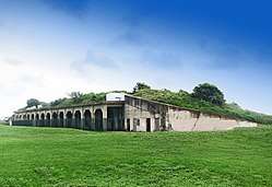 Fort Travis on Bolivar Peninsula | |
 Fort Travis  Fort Travis | |
| Location | SH 87 at Loop 108, Port Bolivar, Texas |
|---|---|
| Coordinates | 29°21′53″N 94°45′29″W |
| Area | 70 acres (28 ha) |
| Built | 1898 |
| NRHP reference No. | 05000247[1] |
| TSAL No. | 8200001368 |
| Significant dates | |
| Added to NRHP | March 30, 2005 |
| Designated TSAL | January 1, 1984 |
Early history
Francisco Xavier Mina built earthworks at Point Bolivar in 1816. James Long established fortifications at the same location in 1819 and built Fort Las Casas in 1820. Long's wife, Jane Herbert Wilkinson Long, was left there after his capture and death, surviving and giving birth to a daughter. Jane became known as "The Mother of Texas"[2] Samuel D. Parr started a settlement in 1838 that would become Port Bolivar.[3] The original Fort Travis was located on the east end of Galveston. The present location was the Confederate Fort Green[4] In 1872 Bolivar Point Lighthouse was constructed north of Fort Travis.
History
The current remaining structures of Fort Travis began in 1898 and ended in 1943. The federal government purchased 97 acres (39 ha) in 1898 and completed Batteries Ernst and Davis. After the 1900 Galveston hurricane a 17 feet (5.2 m) seawall was built for storm protection. Battery Kimball was built in 1925 and Battery No. 236 was completed in 1943. Armament consisted of two twelve-inch guns on Barbette carriages and three-inch rapid-fire guns. In 1949 the installation was declared surplus and sold. In 1973 the Galveston County Commissioners Court purchased the site for use as a public park[5]
Park
The park and playground is located within the boundaries of the historic Fort Travis and is under the jurisdiction of the Galveston County Department of Parks & Cultural Services.[6] There are several amenities such as cabanas (6), camping areas, three covered picnic areas, and three wetland overlooks.[7]
NRHP
The site was added to the National Register of Historic Places in Galveston County on 30 March 2006.
Gallery
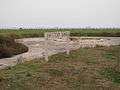 Battery Kimble
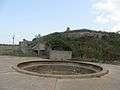 Battery 236
References
- "National Register Information System". National Register of Historic Places. National Park Service. November 2, 2013.
- A. Pat Daniels. "Bolivar Peninsula". Handbook of Texas Online. Texas State Historical Association. Retrieved 2019-07-13.
- A. Pat Daniels. "Port Bolivar, Tx". Handbook of Texas Online. Texas State Historical Association. Retrieved 2019-07-13.
- Linton, Tom (2009-10-26). "Fort Travis Seashore Park has many layers". The Daily News. Retrieved 2019-07-13.
- Darst, Maury. "Fort Travis". Handbook of Texas Online. Texas State Historical Association. Retrieved 2019-07-13.
- "Fort Travis Seashore Park has many layers". Galveston County Department of Parks & Cultural Services. Retrieved 2019-07-13.
- "Parks, Recreation, Open Space and Conservation/Natural Resource Master Plan Galveston, County Texas" (PDF). Galveston County Department of Parks & Cultural Services. 1998. p. 299. Retrieved 2019-07-13. (updated in 2003)