Fort Hancock–El Porvenir International Bridge
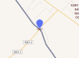
The Fort Hancock–El Porvenir International Bridge (Spanish: Puente El Porvenir) is an international bridge which crosses the Rio Grande connecting the United States–Mexico border cities of Fort Hancock, Texas and El Porvenir, Chihuahua. The two-lane international bridge was constructed in 1936 and is 1,855 feet (565 m) long.[1] The Fort Hancock Port of Entry is located on the Texas side of the bridge and connects to Farm to Market Road 1088.[2][3]
Fort Hancock–El Porvenir International Bridge Puente El Porvenir | |
|---|---|
| Coordinates | 31°16′23″N 105°51′16″W |
| Crosses | Rio Grande |
| Locale | Fort Hancock, Texas |
| Characteristics | |
| Total length | 1,855 feet |
| History | |
| Opened | 1936 |
| |
Border crossing
The Fort Hancock Port of Entry was established when the first bridge was built by the International Boundary and Water Commission in 1936.[4]
gollark: It does work, actually.
gollark: Do not spread such lies.
gollark: No I'm not.
gollark: I bet this is just a convoluted way to pick out `load` and stuff.
gollark: Oh, it's not just `\0` and I misread it, that makes more sense.
References
- "Fort Hancock-El Porvenir Bridge". Texas Department of Transportation. Retrieved December 6, 2014.
- Transportation Planning and Programming Division (n.d.). "Farm to Market Road No. 1088". Highway Designation Files. Texas Department of Transportation. Retrieved December 6, 2014.
- Transportation Planning and Programming Division (2014). Texas County Mapbook (PDF) (Map) (2014 ed.). 1:120,000. Texas Department of Transportation. p. 11. Retrieved December 6, 2014.
- "Fort Hancock-El Porvenir Bridge". Texas Department of Transportation. Retrieved 26 July 2012.
This article is issued from Wikipedia. The text is licensed under Creative Commons - Attribution - Sharealike. Additional terms may apply for the media files.