Forest of Dartmoor
The Forest of Dartmoor is an ancient royal forest covering part of Dartmoor, Devon, England.
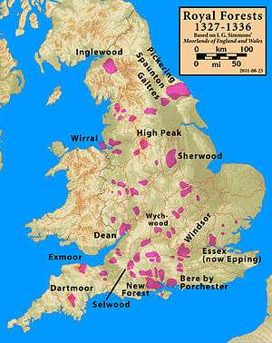
A royal forest was an area reserved by the king for hunting, and William the Conqueror introduced the concept of forest law in England in the 11th century.[1] Until 1204 the whole of Devon was a royal forest, but in that year King John agreed (subject to the payment by the county's commonality of a "fine" of 5,000 marks) to disafforest all of Devon "up to the metes of the ancient regardes of Dertemore and Exmore, as these regardes were in the time of King Henry the First". In other words, all of Devon except for Dartmoor and Exmoor was freed from forest law.[2]
This disafforestation was confirmed by King Henry III in 1217,[3] and in 1239 he granted the Forest of Dartmoor (and the Manor of Lydford) to his brother, Richard, Earl of Cornwall. From that date it technically became a chase, not a forest, though the name did not change.[4] The next year, in a writ dated 13 June 1240, the king directed the Sheriff of Devon and twelve knights of the county to perambulate the Forest to record its exact bounds. This was because Richard had been in dispute with four knights who owned land adjoining the forest. The perambulation (known ever since as "the 1240 Perambulation") took place on 24 July 1240.[3] It was around this time that the first of the Ancient Tenements, such as Babeny, were founded within the Forest.[5]
Richard's son, Edmund inherited the forest, but when he died in 1300 with no heir, the forest reverted to The Crown. King Edward II granted it to his favourite, Piers Gaveston, in 1308; on Gaveston's beheading in 1312, it reverted to The Crown again.[6] Then in 1337 King Edward III granted the forest to Edward, the Black Prince, at the same time as he created him the first Duke of Cornwall,[3] and today, the forest still belongs to the Duchy of Cornwall.[1] A walk that follows the forest bounds as far as possible was set up in 1982.[7]
The "Perambulations"
Although the original document detailing the route of the 1240 Perambulation has been lost, a number of near-contemporary copies still exist, differing only in spelling.[3] A modern transcription of the places mentioned is as follows:[7][8]
| Original text of 1240 (alternative spellings in brackets) | Modern placename | Notes |
|---|---|---|
| …ad hogam de Cossdonne | Cosdon | A prominent hill on the northern edge of Dartmoor |
| et inde linealiter usque ad parvam hogam que vocatur parva Hundetorre, | Hound Tor | |
| et inde linealiter usque ad Thurlestone, | Watern Tor | |
| et inde linealiter usque ad Wotesbrokelakesfote que cadit in Tyng, | Hew Lake Foot | |
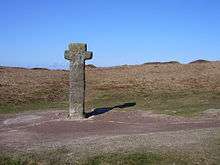
| et inde linealiter usque ad Heigheston (Hengheston) | The Longstone on Shovel Down | A Bronze Age standing stone |
| et inde linealiter usque ad Langestone (Yessetone) | The Heath Stone | |
| et inde linealiter usque per mediam turbariam de Alberysheved (Aberesheved) | The marsh at the head of the Metheral Brook | |
| et sic in longum Wallebroke | Acknowledged to be a scribe's error[9] | |
| et inde linealiter usque ad Furnum regis | King's Oven | |
| et inde linealiter usque ad Wallebrokeshede | The head of the Walla Brook | |
| et sic in longum Wallebroke usque cadit in Dertam, | Along the Walla Brook to its confluence with the East Dart River | |
| et sic per Dertam usque ad aliam Dertam, | Dartmeet | |
| et sic per aliam Dertam ascendendo usque Okebrokysfote, | Up the West Dart River to the foot of the O Brook | |
| et sic ascendendo Okebroke usque ad la Dryeworke, | Up the O Brook to Dry Lake | A tinner's gulley |
| et ita ascendendo usque ad la Dryfeld ford, | The Sandy Way | |
| et sic inde linealiter usque ad Battyshull (Cattyshill, Gnattishull) | Ryder's Hill | |
| et inde linealiter usque ad caput de Wester Wellabroke | The head of the Weston Wella Brook | |
| et sic per Wester Wellabroke usque cadit in Avenam, | Down the Weston Wella Brook to its confluence with the River Avon | |
| et inde linealiter usque ad Ester Whyteburghe | Eastern Whittabarrow | A large cairn |
| et inde linealiter usque ad la Redelake (Rodelake) que cadit in Erme | The confluence of Red Lake and the River Erme | |
| et inde linealiter usque ad Grymsgrove | The head of the River Erme | |
| et inde linealiter usque ad Elysburghe | Eylesbarrow | |
| et sic linealiter usque at crucem Sywardi | Nun's Cross | |
| et inde usque ad Ysfother | South Hessary Tor | |
| et sic per aliam Ysfother | North Hessary Tor | |
| et inde per mediam Mystor (Mistmore) | Great Mis Tor | |
| usque ad Mewyburghe | White Barrow | |
| et inde usque ad Lullingesfote (Hullingssete) | Limsboro Cairn | |
| et inde usque ad Rakernesbrokysfote, | The confluence of the Rattle Brook and the River Tavy | |
| et sic ad caput ejusdem aque | Up the Rattle Brook to its head | |
| et deinde usque ad la Westsolle | Stenga Tor | |
| et inde linealiter usque ad Ernestorre | High Willhays[10] | Some sources say this is Yes Tor |
| et inde linealiter usque at vadum proximum in orientali parte capelle Sancti Michaelis de Halgestoke | Halstock Chapel | |
| et inde linealiter usque ad predictum hogam de Cossdonne in orientali parte | Return to Cosdon |
There was another perambulation of the forest bounds in 1608 which introduced a number of changes and added boundary points between the existing ones.[11] The exact boundaries continued to be unclear or disputed until the later 19th century.[12]
References
- Sandles, Tim. "The Legendary Forest of Dartmoor". Legendary Dartmoor. Retrieved 11 September 2011.
- Brewer 2002, p.15
- Brewer 2002, p.16
- Somers Cocks 1970, p.94
- Somers Cocks 1970, p.96–98
- Milton 2006, p.8
- Sandles, Tim. "The Dartmoor Perambulations". Legendary Dartmoor. Retrieved 11 September 2011.
- Brewer 2002, pp.20–41
- Brewer 2002, p.26
- Brewer 2002, p.39
- Brewer 2002, p.18
- Brewer 2002, map on p.21
Sources
- Brewer, Dave (2002). Dartmoor Boundary Markers. Tiverton, Devon: Halsgrove. ISBN 1-84114-172-0.
- Milton, Patricia (2006). The Discovery of Dartmoor, a Wild and Wondrous Region. Chichester: Phillimore. ISBN 1-86077-401-6.
- Somers Cocks, John (1970). "Saxon and Early Medieval Times". In Crispin Gill (ed.). Dartmoor. A New Study. Newton Abbot: David and Charles. ISBN 0-7153-5041-2.