Florida State Road 694
State Road 694 (SR 694) is an east–west route in Pinellas County, running from SR 693 (66th Street N) in Pinellas Park to U.S. Route 92 (US 92 and unsigned SR 600) in St. Petersburg.
| ||||
|---|---|---|---|---|
| Park Boulevard Gandy Boulevard | ||||
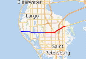
SR 694 in red, CR 694 in blue | ||||
| Route information | ||||
| Length | 6.023 mi[1] (9.693 km) CR 694: 6.991 mi (11.251 km) | |||
| Major junctions | ||||
| West end | ||||
| East end | ||||
| Location | ||||
| Counties | Pinellas | |||
| Highway system | ||||
| ||||


Route description
State Road 694 starts at State Road 693 in Pinellas Park, where SR 694 heads east as Park Boulevard. At the intersection with US 19 in southeastern Pinellas Park, SR 694 becomes known as Gandy Boulevard and turns northeast into northeastern St. Petersburg, heading towards the interchange with Interstate 275 (I-275). It continues northeast, intersecting Dr. Martin Luther King Jr. Street N, before heading towards its eastern terminus at the intersection with 4th Street N, Roosevelt Boulevard, and US 92 (unsigned SR 600). East of SR 694's eastern terminus, Gandy Boulevard continues signed as US 92/SR 600 and crosses the Gandy Bridge into Tampa.
State Road 694 previously began at State Road 699 in Indian Shores, running through Seminole and to the SR 693 intersection in Pinellas Park. The former road to the west is now known as County Road 694 (CR 694).
History
State Road 694 was originally visioned as a multilane freeway, running from SR 699 (Gulf Boulevard) east to the Gandy Bridge, known as the Gandy Freeway. However, the plan was nixed in the 1970s due to an increasing business population. The remnants of this planned freeway are the US 19 interchange in Pinellas Park, the configuration of the I-275 interchange, and the wide median between MLK Jr St N and 4th St N.
Future
Although the possibility of a freeway west of US 19 is dead today, the Gandy Freeway project between I-275 and 4th St is finally becoming reality. The project will cost $83 million and is slated for completion in 2017.[2] The Gandy Freeway east of US 19 has been reconsidered in recent years due to increasing congestion and right-of-way already prepared for overpasses at 4th St N/Roosevelt Blvd and 9th St N/MLK St N.[3]
Major intersections
The entire route is in Pinellas County.
| Location | mi[1][4] | km | Destinations | Notes | |
|---|---|---|---|---|---|
| Indian Shores | 0.000 | 0.000 | Western terminus | ||
| 0.2[5] | 0.32 | Gulf Boulevard Bridge over The Narrows (Gulf Intracoastal Waterway) | |||
| | 0.807 | 1.299 | Oakhurst Road (CR 233 north) | ||
| Seminole | 2.8[5] | 4.5 | |||
| 3.4[5] | 5.5 | ||||
| 4.9[5] | 7.9 | ||||
| Pinellas Park | 6.5[5] | 10.5 | Belcher Road (CR 501) | ||
| 6.991 | 11.251 | West end of state maintenance; CR 694 becomes SR 694 | |||
| 8.741 | 14.067 | ||||
| 9.719 | 15.641 | Interchange | |||
| St. Petersburg | 11.25 | 18.11 | I-275 exit 28; no access from SR 694 west to I-275 north or I-275 south to SR 694 east | ||
| 12.450 | 20.036 | ||||
| 12.915 | 20.785 | No left turn eastbound | |||
| 13.014 | 20.944 | Eastern terminus; Gandy Boulevard continues onto US 92 (SR 600) | |||
1.000 mi = 1.609 km; 1.000 km = 0.621 mi
| |||||
References
- FDOT straight line diagrams Archived March 6, 2014, at the Wayback Machine, accessed March 2014
- "Archived copy". Archived from the original on 2014-02-27. Retrieved 2014-02-28.CS1 maint: archived copy as title (link) ABC Action News - 2014 Feb 20, Retrieved 2014 Feb 28
- Connecting dots to uncork traffic St. Petersburg Times March 2, 2003
- FDOT GIS data Archived 2008-12-11 at the Wayback Machine, accessed January 2014
- Google Maps distance