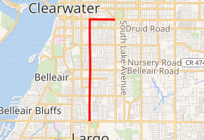
Florida State Road 651
State Road 651 (SR 651) is a 3.798-mile-long (6.112 km) state highway in Pinellas County, Florida, that runs from U.S. Route 19 Alternate and Florida State Road 686 in southern Largo to Florida State Road 60 and County Road 375 in Clearwater. It is unsigned throughout, running concurrent with U.S. Route 19 Alternate for the first 3.041 miles (4.894 km), then with Florida State Road 60 until its terminus.
| ||||
|---|---|---|---|---|

| ||||
| Route information | ||||
| Maintained by FDOT | ||||
| Length | 3.798 mi[1] (6.112 km) | |||
| Major junctions | ||||
| South end | ||||
| North end | ||||
| Location | ||||
| Counties | Pinellas | |||
| Highway system | ||||
| ||||
Major intersections
The entire route is in Pinellas County.
| Location | mi[1] | km | Destinations | Notes | |||
|---|---|---|---|---|---|---|---|
| Largo | 0.000 | 0.000 | Southern terminus; southern end of US 19 Alt. concurrency; continues as US 19 Alt. beyond SR 686 | ||||
| see U.S. Route 19 Alt. (see mile 17.066-20.107) | |||||||
| Clearwater | 3.041 | 4.894 | Northern end of US 19 Alt. concurrency; southern end of SR 60 concurrency | ||||
| see SR 60 (mile 2.725-3.482) | |||||||
| Clearwater | 3.798 | 6.112 | Northern terminus; northern end of SR 60 concurrency; continues beyond South Highland Avenue as SR 60 | ||||
| 1.000 mi = 1.609 km; 1.000 km = 0.621 mi | |||||||
gollark: Anyway, mine is highly efficient. It's O(1) because the strings are canonically limited to 512 bytes.
gollark: I would never pretend to be myself and never have (unless I would), and I'm not* even in this round so you shouldn't guess me.
gollark: I do write all of them...
gollark: Like the TIO one and the one which rickrolled you.
gollark: There were several with links in.
References
External links
This article is issued from Wikipedia. The text is licensed under Creative Commons - Attribution - Sharealike. Additional terms may apply for the media files.
