Florida State Road 442
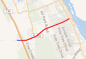
State Road 442 (SR 442) is a short east–west route in Volusia County connecting U.S. Route 1 (US 1) in Edgewater with Interstate 95 (I-95) at exit 244. The road is named Indian River Boulevard.
| ||||
|---|---|---|---|---|

SR 442 in red, CR 442 in blue | ||||
| Route information | ||||
| Maintained by FDOT | ||||
| Length | 3.780 mi[1] (6.083 km) | |||
| Major junctions | ||||
| West end | ||||
| East end | ||||
| Location | ||||
| Counties | Volusia | |||
| Highway system | ||||
| ||||
Route description
West of I-95, the paved road begins as the unsigned County Road 442 (CR 442) providing access to rural ranches. The divided highway runs for about 0.19 miles (0.31 km) before transitioning to SR 442 just west of the I-95 interchange. After the interchange, Indian River Boulevard continues east-northwest as a divided highway passing under a pedestrian bridge for the East Central Regional Rail Trail and intersecting Old Mission Road (CR 4137). After spending its first two miles (3.2 km) in a more rural section of the city, the two roadway carriages come together and pass through a residential neighborhood of Edgewater. SR 442 crosses a railroad and enters a more commercialized part of the city. The state highway ends at a signalized intersection with US 1 (SR 5) with the road continuing east for another 800 feet (240 m) as East Indian River Boulevard.[2]
Major intersections
The entire route is in Edgewater, Volusia County.
| mi[1] | km | Destinations | Notes | ||
|---|---|---|---|---|---|
| 0.000 | 0.000 | Elkcam Boulevard (CR 442) | West end of state maintenance | ||
| 0.007– 0.187 | 0.011– 0.301 | I-95 exit 244 | |||
| 3.780 | 6.083 | ||||
| 1.000 mi = 1.609 km; 1.000 km = 0.621 mi | |||||
References
- Transportation and Data Analytics Office (August 13, 2018). "Straight Line Diagram of Road Inventory". Florida Department of Transportation. Retrieved April 18, 2020.
- Google (April 18, 2020). "Florida State Road 442" (Map). Google Maps. Google. Retrieved April 18, 2020.
