Florida State Road 295
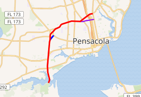
State Road 295 (SR 295) is a major highway in the Pensacola metropolitan area. Locally, SR 295 is also called Navy Boulevard, New Warrington Road, and Fairfield Drive. The Southern terminus is at the entrance to Pensacola Naval Air Station, and the northern terminus is at an intersection with Fairfield Drive, Ninth Avenue (SR 289) and 12th Avenue in the city of Pensacola. This roadway is the main artery between southwestern Escambia County and the city of Pensacola.
| |||||||
|---|---|---|---|---|---|---|---|

SR 295 in red, SR 295 Spur in blue, SR 752 in purple | |||||||
| Route information | |||||||
| Maintained by FDOT | |||||||
| Length | 7.992 mi[1] (12.862 km) | ||||||
| Major junctions | |||||||
| South end | Naval Air Station Pensacola | ||||||
| North end | |||||||
| Location | |||||||
| Counties | Escambia | ||||||
| Highway system | |||||||
| |||||||
Major intersections
The entire route is in Escambia County.
| Location | mi[1] | km | Destinations | Notes | |
|---|---|---|---|---|---|
| Warrington | 0.000 | 0.000 | Naval Air Station Pensacola | ||
| 0.956 | 1.539 | ||||
| West Pensacola | 1.689 | 2.718 | South end of US 98 / SR 30 overlap | ||
| 2.054 | 3.306 | North end of US 98 / SR 30 overlap | |||
| 2.299 | 3.700 | ||||
| 3.042 | 4.896 | Jackson Street (CR 298A) | |||
| 3.364 | 5.414 | Spur of SR 295 | |||
| 3.98 | 6.41 | interchange; northbound exit and southbound entrance | |||
| 3.98 | 6.41 | interchange; southbound exit and northbound entrance | |||
| 4.704 | 7.570 | interchange; southbound exit and northbound entrance | |||
| 5.725 | 9.213 | ||||
| 5.929 | 9.542 | North T Street (CR 493 south) | |||
| Goulding | 8.313 | 13.378 | |||
| 6.724 | 10.821 | northbound exit and southbound entrance | |||
| Pensacola | 6.957 | 11.196 | |||
| 7.51 | 12.09 | I-110 exit 4 | |||
| 7.596 | 12.225 | ||||
| 7.992 | 12.862 | ||||
1.000 mi = 1.609 km; 1.000 km = 0.621 mi
| |||||
Related routes
West Pensacola spur
A spur on New Warrington Road in West Pensacola is also signed as SR 295. The spur is designed as a connection from northbound SR 295 and to southbound SR 295 to US 90.
The entire route is in West Pensacola, Escambia County.
| mi[1] | km | Destinations | Notes | ||
|---|---|---|---|---|---|
| 0.000 | 0.000 | ||||
| 0.326 | 0.525 | ||||
| 0.423 | 0.681 | North Old Corry Field Road (CR 295A south) | |||
| 0.482 | 0.776 | ||||
| 1.000 mi = 1.609 km; 1.000 km = 0.621 mi | |||||
State Road 752
| |
|---|---|
| Location | Pensacola |
A one-mile-long spur from SR 295 (along Texar Drive) to Ninth Avenue is signed east–west as State Road 752. While SR 295 has a diamond interchange with Interstate 110 (I-110), SR 752 does not connect with the Interstate highway at all.
The entire route is in Escambia County.
| Location | mi[1] | km | Destinations | Notes | |
|---|---|---|---|---|---|
| Goulding | 0.000 | 0.000 | |||
| 0.207 | 0.333 | ||||
| Pensacola | 0.294 | 0.473 | |||
| 0.926 | 1.490 | ||||
| 1.000 | 1.609 | ||||
| 1.182 | 1.902 | ||||
| 1.000 mi = 1.609 km; 1.000 km = 0.621 mi | |||||
References
- FDOT straight line diagrams Archived March 6, 2014, at the Wayback Machine, accessed March 2014
