Florida State Road 105
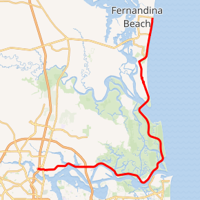
State Road 105 (SR 105) is a 36.818-mile-long (59.253 km) north-south state highway in northeastern Jacksonville, Florida. It travels from an interchange with Interstate 95 (I-95) just north of downtown eastward (signed north) along the north bank of the St. Johns River to an intersection with SR A1A, at the Mayport Ferry, and then along SR A1A to the end of SR 200 in Fernandina Beach.
| ||||
|---|---|---|---|---|

SR 105 highlighted in red | ||||
| Route information | ||||
| Maintained by FDOT | ||||
| Length | 36.818 mi[1] (59.253 km) | |||
| Major junctions | ||||
| South end | ||||
| North end | ||||
| Highway system | ||||
| ||||
SR 105 is the only access road to the Jacksonville Zoo and Gardens. In fact, the entire road was named Heckscher Drive for years. However, the section from I-95 east to I-295 East Beltway was renamed Zoo Parkway.
Route description
SR 105 begins at an interchange with I-95.[2] SR 105 has an interchange with U.S. Route 17 (US 17) less than 1 mile (1.6 km) from its western terminus. From there, SR 105 can be characterized as a four-lane mid-speed highway that parallels the north bank of the St. Johns River through a rural area.[3][4] After 5.9 miles (9.5 km), traffic slows down briefly to a pair of traffic lights. In between the traffic lights, there are on-ramps for access to Interstate 295 (I-295).[5] After the traffic lights, SR 105 begins to travel through marshland along the St. Johns River. The speed limit for this portion of the road is 45 miles per hour (72 km/h).[6] During this stretch, SR 105 intersects all the roads that cross the St. Johns River. After intersecting Dave Rawls Boulevard, SR 105 thins down to a two-lane highway. The road proceeds to travel through mostly marshland, crossing over Little Clapboard Creek and Sisters Creek.[7][8] After 9.3 miles (15.0 km) of travelling through marshland, SR 105 intersects SR A1A, which crosses the St. Johns River via the Mayport Ferry.[9] At this point, signage disappears for SR 105 as it converges with SR A1A.[10] SR 105 follows SR A1A over Fort George Inlet and through Little Talbot Island State Park and Big Talbot Island State Park.[11] SR 105 then crosses the mouth of the Nassau River into Amelia City.[12] SR 105 follows the beach due north until its reaches its western terminus in Fernandina Beach.[13]
History
SR 105 travels concurrent with SR A1A from the Mayport Ferry up to Fernandina Beach, however, over the years, signage has been removed.
Major intersections
| County | Location | mi[1] | km | Destinations | Notes |
|---|---|---|---|---|---|
| Duval | Jacksonville | 0.000 | 0.000 | Exit 358 on I-95 | |
| 0.542 | 0.872 | Trumpet interchange | |||
| 3.681 | 5.924 | Bridge over Broward River | |||
| 4.977 | 8.010 | Bridge over Dunn Creek | |||
| 6.034 | 9.711 | Exit 41 on I-295 (East Beltway) | |||
| 7.026 | 11.307 | Bridge over San Carlos Creek | |||
| 7.293 | 11.737 | Blount Island Marine Terminal | Partial interchange with Dave Rawis Boulevard | ||
| 8.160 | 13.132 | Bridge over Browns Creek | |||
| 9.759 | 15.706 | Bridge over Clapboard Creek | |||
| 13.112 | 21.102 | Bridge over Sisters Creek | |||
| 15.061 | 24.238 | Southern terminus of concurrency with SR A1A | |||
| Bridge over Fort George River | |||||
| Nassau Sound | Nassau Sound Bridge | ||||
| Nassau | Fernandina Beach | Traffic circle; eastern terminus of CR 108; former SR 108 | |||
| 36.818 | 59.253 | Northern terminus of SR 105; eastern terminus of SR 200 | |||
1.000 mi = 1.609 km; 1.000 km = 0.621 mi
| |||||
See also


- List of state roads in Florida
References
- FDOT straight line diagrams Archived March 6, 2014, at the Wayback Machine, accessed March 2014
- https://www.google.com/maps/place/Florida+105/@30.4091845,-81.653624,16z/data=!4m2!3m1!1s0x88e5b2facc77590b:0xaed418c3ce4734a7
- https://www.google.com/maps/@30.407482,-81.653235,3a,75y,51.03h,66.49t/data=!3m4!1e1!3m2!1sFBuDZOTRqVYiBeLx-QDkpQ!2e0
- https://www.google.com/maps/@30.413517,-81.617614,3a,75y,23.82h,58.28t/data=!3m4!1e1!3m2!1szetzzfiPLkME2CFbOIVVpQ!2e0
- https://www.google.com/maps/@30.412166,-81.567028,3a,75y,43.38h,95.58t/data=!3m4!1e1!3m2!1s0FdbmtS7AF6LV0Ff--7RrQ!2e0
- https://www.google.com/maps/@30.412048,-81.557014,3a,40.9y,100.35h,77.31t/data=!3m4!1e1!3m2!1sl2nc5gVJzrNN7QacdQQWlA!2e0
- https://www.google.com/maps/dir/Heckscher+Dr,+Jacksonville,+FL+32218/30.4121945,-81.5647058/@30.4015663,-81.5111267,14z/data=!4m8!4m7!1m5!1m1!1s0x88e5b05065116417:0x1711de71843080c4!2m2!1d-81.6574959!2d30.4084751!1m0
- https://www.google.com/maps/@30.416115,-81.54142,3a,75y,52.55h,83.87t/data=!3m4!1e1!3m2!1sgDAauDYSbK_lfUW0FcC19A!2e0
- https://www.google.com/maps/@30.3946295,-81.4326374,17z
- https://www.google.com/maps/@30.395595,-81.437152,3a,75y,303.6h,70.4t/data=!3m4!1e1!3m2!1ssctEV-h2R4uN3qlVdofm2w!2e0
- https://www.google.com/maps/@30.4539151,-81.4316697,13z
- https://www.google.com/maps/@30.5148311,-81.4522983,12z
- https://www.google.com/maps/@30.6590828,-81.3832536,12z
