Flag (crater)
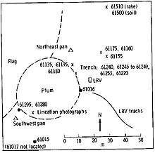
Flag crater is a small crater in the Descartes Highlands of the Moon visited by the astronauts of Apollo 16. The name of the crater was formally adopted by the IAU in 1973.[1] Geology Station 1 is adjacent to Flag, at the much smaller Plum crater.
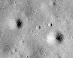 Apollo 16 image, with Flag left of center and Spook right of center. Plum is the tiny crater on the southeast rim of Flag. | |
| Coordinates | 8.97°S 15.45°E |
|---|---|
| Diameter | 240 m[1] |
| Eponym | Astronaut-named feature |
On April 21, 1972, the Apollo 16 Apollo Lunar Module (LM) Orion landed about 1.5 km east of Flag, which is between the prominent North Ray and South Ray craters. The astronauts John Young and Charles Duke explored the area over the course of three EVAs using a Lunar Roving Vehicle, or rover. They drove to Flag on EVA 1.
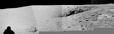
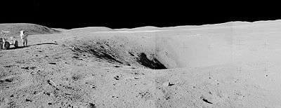
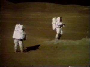

Flag crater is approximately 240 m in diameter and over 20 m deep.[2] The adjacent crater Plum is only about 30 m in diameter.[3] The slightly larger crater Spook, also visited by the astronauts, lies less than 1 km to the east.
Samples
The following samples were collected from the vicinity of Plum and Flag crater (Station 1), as listed in Table 6-II of the Apollo 16 Preliminary Science Report,[5] which does not include samples smaller than 25 g weight (of which there were many). Sample type, lithology, and descriptions are from the Lunar Sample Atlas of the Lunar and Planetary Institute.[6]
| Sample | Sample Type | Lithology | Photo | Description |
|---|---|---|---|---|
| 61015 | rock | breccia | 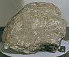 | coated with black glass on one side and is thought to be ejecta from
South Ray crater |
| 61016 | rock | impact melt breccia | 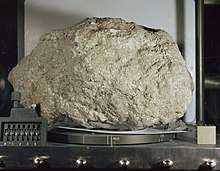 | known as Big Muley; named after Bill Muehlberger,
the leader of the Apollo 16 field geology team |
| 61135 | rock | regolith breccia | 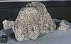 | an ancient regolith breccia that became a closed system
about 3.9 b.y. ago; and has a few zap pits |
| 61155 | rake | breccia | clast-rich "glassy impact melt"; has abundant white clasts,
thin glass veins and glassy mesostasis | |
| 61156 | rock | impact melt breccia | 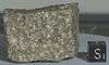 | Tough, medium gray, poikilitic impact melt
that has been thermally metamorphosed |
| 61175 | rock | fragmental breccia | 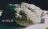 | Contains a high percentage of glass, with some agglutinate.
It also contains a small, but significant, mare component |
| 61195 | rock | breccia | 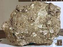 | coherent, medium grey breccia with a glassy matrix and abundant clasts;
zap pits are surrounded with wide spall zones |
| 61295 | rock | breccia | friable light matrix breccia with both light and dark clasts;
rounded and has many zap pits | |
| 61536 | rake | breccia | 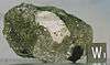 | contains a large white clast held within a glass matrix,
and has a thin glass coating on surface |
| 61546 | rake | breccia |  | vesicular chunk of glass with numerous small white clasts
and micrometeorite craters on one side only |
External links
- Apollo 16 Traverses, 78D2S2(25), Lunar and Planetary Institute
References
- Flag, Gazetteer of Planetary Nomenclature, International Astronomical Union (IAU) Working Group for Planetary System Nomenclature (WGPSN)
- Apollo 16 Landing Area, 78D2S1(50), NASA Lunar Topophotomap. Published by The Defense Mapping Agency, November 1974. Available from Lunar and Planetary Institute.
- Plum, Gazetteer of Planetary Nomenclature, International Astronomical Union (IAU) Working Group for Planetary System Nomenclature (WGPSN)
- Geologic Map of the Apollo 16 (Descartes) Landing Area by Apollo Field Geology Investigation Team (D. P. Elston, E. L. Boudette, J. P. Schafer), United States Geological Survey, April 1972
- Apollo 16 Preliminary Science Report (NASA SP-315), 1972
- Lunar Sample Atlas, Lunar and Planetary Institute