Five Fingers Group
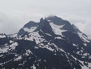
The Five Fingers Group (also known as The Five Fingers) is a group of summits on the divide between Pitt Lake and Coquitlam Lake and north of Widgeon Lake, in British Columbia, Canada.[1][2] The nearest populated areas are Anmore and Coquitlam. The peaks, all part of the same massif, are named for the fingers of a hand, but none of the names are official[3][3][4][5]

The Five Fingers group as seen from a helicopter over Pitt Lake
The area is extremely remote and inaccessible. Its slopes on the Coquitlam River drainage are a major watershed and on that side, access is forbidden.
The peaks are:
- Middle Finger (mountain) 1,890 m (6,201 ft), the highest
- The Thumb (mountain) 1,815 m (5,955 ft)
- The Forefinger (mountain) 1,741 m (5,712 ft)
- Little Finger (mountain) 1,732 m (5,682 ft)
Notes
- Fairley p250
- Canadian Mountain Encyclopedia Five Fingers Group
- Canadian Mountain Encyclopedia Middle Finger
- Canadian Mountain Encyclopedia The Forefinger
- Canadian Mountain Encyclopedia Little Finger
gollark: Fun fact, ale: if you run a banned program in potatOS, this is logged in the CLOUD™.
gollark: PotatOS doesn't have a git repo, 'twould be annoying to do.
gollark: Do YOU know about the PotatOS Incident Report logs?
gollark: Prove it.
gollark: I knew about it.
References
- Fairley, Bruce (1986). "Chapter 22: Coquitlam-Pitt". A Guide to Climbing and Hiking in Southwestern British Columbia. Gordon Soules Book Publishers Ltd. p. 250. ISBN 0-919574-99-8. ISSN 0068-8207.
- "Middle Finger". Canadian Mountain Encyclopedia. Retrieved 2007-02-18.
- "The Forefinger". Canadian Mountain Encyclopedia. Retrieved 2007-02-18.
- "The Thumb". Canadian Mountain Encyclopedia. Retrieved 2007-02-18.
- "Little Finger". Canadian Mountain Encyclopedia. Retrieved 2007-02-18.
- "Five Finger Group". Canadian Mountain Encyclopedia. Archived from the original on 2007-09-30. Retrieved 2007-02-18.
This article is issued from Wikipedia. The text is licensed under Creative Commons - Attribution - Sharealike. Additional terms may apply for the media files.