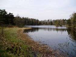
Fatburen
Fatburen is a small lake in Tyresö Municipality, south-east of central Stockholm, Sweden. It is the last and easternmost lake within the Tyresån Lake System.
| Fatburen | |
|---|---|
 | |
| Location | Stockholm |
| Coordinates | 59°13′58″N 18°17′30″E |
| Primary inflows | Albysjön |
| Primary outflows | Kalvfjärden |
| Basin countries | Sweden |
| Surface area | 0.030 km2 (0.012 sq mi)[1] |
| Average depth | 1.9 m (6 ft 3 in)[2] |
| Max. depth | 5.0 m (16.4 ft)[2] |
| Water volume | 0.895 km3 (726,000 acre⋅ft)[2] |
| Surface elevation | 13.7 m (45 ft)[1] |
| Settlements | Tyresö |
| References | [1][2] |
The lake is roughly triangular in shape with its inflow from Albysjön in the southern corner, and its outflow to Kalvfjärden in the north-eastern corner. It is separated from Albysjön by the peninsula Rävnäset, a municipal nature reserve covering 27 ha.[3] It contains a wide range of rare species and is together with the nature and park surrounding Tyresö Palace one of the best locales for bats.[4] South-east of the lake is the residential area Solberga.
In summers, the lake is part of a popular walk for visitors attracted by the Tyresö Palace and its surroundings.[5] In winters, the lake is popular for ice fishing.[6]
There are 21 species of vascular plants by the lake which in itself contains 9-13 aquatic plants, a relatively high biodiversity within the lake system.[1] Common fishes include Perch, Pike, and Zander.[7]
Notwithstanding its eutrophication, the presence of Stoneworts in Fatburen indicates the waters have a relatively high visibility, which, considering it is the last lake in the lake system, is surprising.[4]
Notes
- Södertörnsekologerna
- SMHI, Sjödjup och sjövolym
- Tyresö Municipality, Rävnäset
- Tyresö Municipality, Naturinventering 1998
- SNF, Tyresö slott och Nyfors
- Tyresö Municipality, Tyresåns sjösystem
- Sportfiskarna, Sportfiskekortet
References
- "Vattenväxter i sjöarna på Södertörn och i angränsande områden samt uppbyggnad av en sjödatabas" (PDF) (in Swedish). Södertörnsekologerna. pp. Appendix 7, p 2. Archived from the original (PDF) on 2007-10-07. Retrieved 2008-02-23.
- "Sjödjup och sjövolym" (PDF) (in Swedish). Swedish Meteorological and Hydrological Institute. 199-10-29. Retrieved 2008-03-02. Check date values in:
|date=(help) ("Lake depth and lake volume") - "Tyresåns sjösystem" (in Swedish). Tyresö Municipality. Archived from the original on 2007-09-27. Retrieved 2008-03-02.
- "Sportfiskekortet" (in Swedish). SportFiskarna. Retrieved 2008-03-03.
- "Tyresö slott och Nyfors" (in Swedish). Svenska naturskyddsföreningen (SNF, Swedish Nature Preservation Society). Archived from the original on 2008-04-08. Retrieved 2008-03-03.
- "Rävnäset" (in Swedish). Tyresö Municipality. 2007-07-05. Archived from the original on 2007-10-11. Retrieved 2008-03-03.
- "Naturinventering 1998" (PDF) (in Swedish). Tyresö Municipality. Archived from the original (PDF) on 2007-10-14. Retrieved 2008-03-03.
External links
- "Bathymetric map of Fatburen and albysjön" (PDF) (in Swedish). Tyresö Municipality / Tyresån Collaboration. 1965. Archived from the original (PDF) on 2009-08-24. Retrieved 2008-03-03.