Farm to Market Road 2546
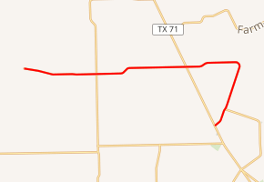
Farm to Market Road 2546 (FM 2546) is a state highway in the U.S. state of Texas that stays within Wharton County. The two-lane road starts at Mount Pilgrim Baptist Church and goes directly west past FM 1160 and State Highway 71 (SH 71). East of SH 71, the highway turns sharply to the southwest and ends at SH 71 north of El Campo.
| ||||
|---|---|---|---|---|
| ||||
| Route information | ||||
| Maintained by TxDOT | ||||
| Length | 13.051 mi[1] (21.004 km) | |||
| Existed | October 31, 1958[1]–present | |||
| Major junctions | ||||
| East end | County Road 394 at Mount Pilgrim Church | |||
| West end | ||||
| Location | ||||
| Counties | Wharton | |||
| Highway system | ||||
| ||||

Route description
FM 2546 starts at a rural intersection in front of Mount Pilgrim Baptist Church. The paved highway ends at this location. From here, gravel-topped County Road 394 continues west and another gravel road goes north. From the church east to FM 1160 at the site of Hahn is 3.3 miles (5.3 km). The distance from FM 1160 eastward to SH 71 is 4.2 miles (6.8 km). The Hahn Cemetery is on the south side of the road along this stretch of FM 2546. Continuing east of SH 71, the highway passes through the tiny community of Jones Creek. At a distance of 2.3 miles (3.7 km) east of SH 71, FM 2546 turns sharply to the southwest. After going southwest an additional 2.3 miles (3.7 km) the highway comes to the intersection with FM 2765. Continuing to the southwest for 1.0 mile (1.6 km), FM 2546 ends at a stop sign on SH 71. The continuation of the road on the west side of SH 71 is called Sandy Corners Road.[2]
History
FM 2546 was originally designated on October 31, 1958 to start at FM 1160 and run approximately 4.3 miles (6.9 km) eastward to a point on SH 71 which was 1.7 miles (2.7 km) southeast of New Taiton in Wharton County. On May 2, 1962 the highway was extended west from FM 1160 about 3.5 miles (5.6 km), making a total distance of approximately 7.7 miles (12.4 km). On May 5, 1966, FM 2546 was extended east from SH 71 a distance of about 2.4 miles (3.9 km). From this point, the highway followed 3.3 miles (5.3 km) of the former right-of-way of FM 2923 to end at SH 71 at a location 2.2 miles (3.5 km) north of the El Campo city limit.[1] FM 2923 was canceled on May 18, 1966.[3]
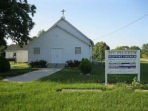 Mt Pilgrim Baptist Church is at the western end of FM 2546 where the pavement ends.
 FM 1160 and FM 2546 meet at the site of Hahn.
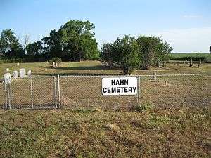 Hahn Cemetery is on FM 2546 east of FM 1160.
Major intersections
The entire highway is in Wharton County.
| Location | mi | km | Destinations | Notes | |
|---|---|---|---|---|---|
| Pin Oak | 0.0 | 0.0 | County Road 394 | Western terminus of FM 2546 | |
| Hahn | 3.3 | 5.3 | |||
| | 7.5 | 12.1 | |||
| | 12.1 | 19.5 | Northern terminus of FM 2765 | ||
| | 13.1 | 21.1 | Eastern terminus of FM 2546 | ||
| 1.000 mi = 1.609 km; 1.000 km = 0.621 mi | |||||
See also


References
- Transportation Planning and Programming Division (n.d.). "Farm to Market Road No. 2546". Highway Designation Files. Texas Department of Transportation. Retrieved June 23, 2013.
- Google (June 23, 2013). "Farm to Market Road 2546" (Map). Google Maps. Google. Retrieved June 23, 2013.
- Transportation Planning and Programming Division (n.d.). "Farm to Market Road No. 2923". Highway Designation Files. Texas Department of Transportation. Retrieved June 23, 2013.