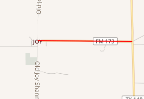
Farm to Market Road 173
Farm to Market Road 173 (FM 173) is a short farm to market road in Clay County, Texas.[1]
| ||||
|---|---|---|---|---|

| ||||
| Route information | ||||
| Maintained by TxDOT | ||||
| Length | 0.944 mi[1] (1.519 km) | |||
| Existed | 1945–present | |||
| Major junctions | ||||
| West end | Old Joy–Shannon Rd. in Joy | |||
| East end | ||||
| Location | ||||
| Counties | Clay | |||
| Highway system | ||||
| ||||
Route description
FM 173's western terminus is in the unincorporated community of Joy, at an intersection with Old Joy–Shannon Road. The road travels approximately 0.9 miles (1.4 km) to the east before ending at SH 148, which connects to Henrietta to the north and Jacksboro to the south.[2]
FM 173 is two-lane and shoulderless for its entire length. It is the shorterst farm to market road in Clay County, and one of the shortest in the state.
History
FM 173 was designated on June 11, 1945. Its routing has not changed.[1]
Major intersections
The entire route is in Clay County.
| Location | mi[3] | km | Destinations | Notes | |
|---|---|---|---|---|---|
| Joy | 0.0 | 0.0 | Old Joy–Shannon Rd. | Western terminus | |
| | 0.9 | 1.4 | Eastern terminus | ||
| 1.000 mi = 1.609 km; 1.000 km = 0.621 mi | |||||
gollark: I use a somewhat experimental homeserver to save resources so some things are a bit broken.
gollark: I think so.
gollark: Admittedly the homeserver protocol is kind of horribly complex so there's only one big *implementation* which federates properly, but you can host it.
gollark: Yes.
gollark: Yep.
References
- Transportation Planning and Programming Division (n.d.). "Farm to Market Road No. 173". Highway Designation Files. Texas Department of Transportation. Retrieved 2011-04-06.
- Transportation Planning and Programming Division (2012). Texas County Mapbook (PDF) (Map) (2012 ed.). 1:120,000. Texas Department of Transportation. p. 389. OCLC 867856197. Retrieved 2011-04-06.
- Google (2011-04-06). "Overview map of Farm to Market Road 173 Distances Between Interchanges" (Map). Google Maps. Google. Retrieved 2011-04-06.
This article is issued from Wikipedia. The text is licensed under Creative Commons - Attribution - Sharealike. Additional terms may apply for the media files.
