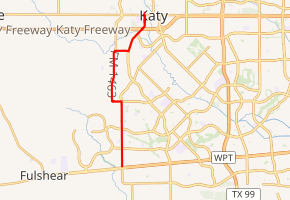
Farm to Market Road 1463
Farm to Market Road 1463 (FM 1463) is a 7.349-mile (11.827 km) farm to market road in Fort Bend County, Texas.[1]
| ||||
|---|---|---|---|---|

| ||||
| Route information | ||||
| Maintained by TxDOT | ||||
| Length | 7.349 mi[1] (11.827 km) | |||
| Major junctions | ||||
| South end | ||||
| North end | ||||
| Location | ||||
| Counties | Fort Bend | |||
| Highway system | ||||
| ||||
Route description
FM 1463 begins in rural Fort Bend county, at an intersection with FM 1093 / FM 359.[2] The route travels north through rural areas of Fort Bend County before entering Katy. It has a junction with IH 10 at its Exit #740. After crossing the interstate, the route continues through Katy, passing Katy High School, before ending at an intersection with US 90 near the Waller County and Harris County lines.[1]
History
FM 1463 was first designated on July 22, 1949, along its current routing; its purpose was to connect Katy to the community of Flewellen.[1] The community. near the intersection of FM 1093, FM 359, and FM 1463, existed at least through the 1980s.[3] However, it does not currently appear on TxDOT's maps.[2]
Major intersections
The entire route is in Fort Bend County.
| Location | mi[4] | km | Destinations | Notes | |
|---|---|---|---|---|---|
| | 0.0 | 0.0 | Southern terminus | ||
| Katy | 6.7 | 10.8 | I-10 west exit 740. | ||
| 7.4 | 11.9 | Northern terminus | |||
| 1.000 mi = 1.609 km; 1.000 km = 0.621 mi | |||||
References
- Transportation Planning and Programming Division (n.d.). "Farm to Market Road No. 1463". Highway Designation Files. Texas Department of Transportation. Retrieved 2011-01-13.
- Transportation Planning and Programming Division (2012). Texas County Mapbook (PDF) (Map) (2012 ed.). 1:120,000. Texas Department of Transportation. p. 541. OCLC 867856197. Retrieved 2011-01-13.
- Stephen L. Hardin. "Flewellen, TX". Handbook of Texas Online. Retrieved 2011-01-13.
- Google (2011-01-13). "Overview map of Farm to Market Road 1463 Distances Between Interchanges" (Map). Google Maps. Google. Retrieved 2011-01-13.
