Farm to Market Road 118
Farm to Market Road 118 (FM 118) is a 11.392-mile (18.334 km) farm to market road in Hunt County, Texas.[1]
| |||||||
|---|---|---|---|---|---|---|---|
| |||||||
| Route information | |||||||
| Length | 11.392 mi[1] (18.334 km) | ||||||
| Existed | 1945–present | ||||||
| Major junctions | |||||||
| South end | |||||||
| North end | |||||||
| Highway system | |||||||
| |||||||

Route description
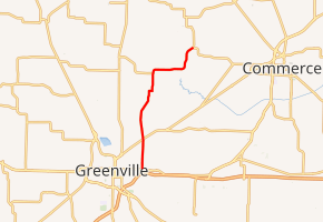
FM 118 begins at FM 499 (the former route of US 67 prior to the construction of IH 30) in eastern Greenville.[1][2][3] It travels to the north, crossing SH 224 just north of the city. It has an intersection with FM 1566, where the road turns to the east.[4] FM 118 soon resumes a northerly direction before ending at FM 512 in the community of South Sulphur, west of Commerce.[1][4]
A spur connection connects FM 118 to the community of Jacobia. While signed as Spur 118 using the standard state "Spur" shield, it is not related to the route officially designated Spur 118 (now Loop 118), located in Denton County.[1][5]
History
FM 118 was designated on January 11, 1945 from US 67 east of Greenville at Ardis Heights north 2.5 miles to SH 24 (now SH 224) northeast of Greenville. On June 25, 1945, the road was extended to Jacobia. On February 21, 1946, the SH 24-US 67 section was cancelled and redesignated as State Highway 355, but this section became part of FM 118 again on July 1, 1947. The final change was on January 16, 1953, when FM 118 was extended to FM 512 in South Sulphur (replacing FM 1738) and a spur connection in Jacobia was added.[1]
On June 21, 2015, the bridge that crosses the South Sulphur River collapsed because of flooding.[6]
Major intersections
The entire route is in Hunt County.
| Location | mi[7] | km | Destinations | Notes | |
|---|---|---|---|---|---|
| Greenville | 0.0 | 0.0 | Southern terminus | ||
| | 2.1 | 3.4 | |||
| Jacobia | 5.9 | 9.5 | |||
| | 7.2 | 11.6 | |||
| South Sulphur | 11.3 | 18.2 | Northern terminus | ||
| 1.000 mi = 1.609 km; 1.000 km = 0.621 mi | |||||
References
- Transportation Planning and Programming Division (n.d.). "Farm to Market Road No. 118". Highway Designation Files. Texas Department of Transportation. Retrieved 2011-01-06.
- Transportation Planning and Programming Division (n.d.). "Farm to Market Road No. 499". Highway Designation Files. Texas Department of Transportation. Retrieved 2011-01-06.
- Transportation Planning and Programming Division (2012). Texas County Mapbook (PDF) (Map) (2012 ed.). 1:120,000. Texas Department of Transportation. p. 506. OCLC 867856197. Retrieved 2011-01-06.
- Transportation Planning and Programming Division (2012). Texas County Mapbook (PDF) (Map) (2012 ed.). 1:120,000. Texas Department of Transportation. p. 528. OCLC 867856197. Retrieved 2011-01-06.
- Transportation Planning and Programming Division (n.d.). "State Highway Loop No. 118". Highway Designation Files. Texas Department of Transportation. Retrieved 2011-01-06.
- "Couple rescued after Hunt County bridge collapse". Archived from the original on 2015-06-23. Retrieved 2015-06-23.
- Google (2011-01-05). "Overview map of Farm to Market Road 118 Distances Between Interchanges" (Map). Google Maps. Google. Retrieved 2011-01-05.